Objective 5 Reduce traffic queues, noise and disturbance in the neighbourhood and improve access to public transport and pedestrian/cycle connectivity to the south and west.
5.1.1 There are limits to the extent to which policies proposed in this Draft Plan can help to achieve the above objective. All policies proposed in the StQW Plan need to relate to ‘the development and use of land’ within the neighbourhood area. It so happens that a key development site within the StQW neighbourhood (at 301 Latimer Road) has a significant potential part to play in transport strategy for the wider area. It is partly on this basis that this section of the Plan is included.
5.1.2 Responses to the StQW Survey showed that transport and traffic issues are a real concern for local residents, shops and businesses. The issues which this Plan seeks to address are as follows:
- Levels of accessibility to public transport are lower in the StQW neighbourhood than for most parts of the borough, and comparatively low for inner London
- In responses to an open question ‘what are the main problems in the area for motorists?’ the impact of worsening traffic queues at the junction of North Pole Road and Wood lane were referred to in 31% of responses to the StQW survey.
- There is local concern that the cumulative impacts of proposed new developments in the White City OA, Old Oak and Park Royal Development Corporation area, and Kensal Rise OA, on traffic congestion along the A219 Woods Lane/Scrubs Lane, are not being taken into account in masterplans. Forecasts, and consultancy reports put together by developers tend to ignore cumulative impacts.
- North Kensington is unusual for an Inner London Borough in having no Underground, Overground or mainline railway station, north of Latimer Road Underground on the Hammersmith & City Line. Access to any form of rail transport is therefore comparatively poor at present. The StQW Plan seeks to address this.
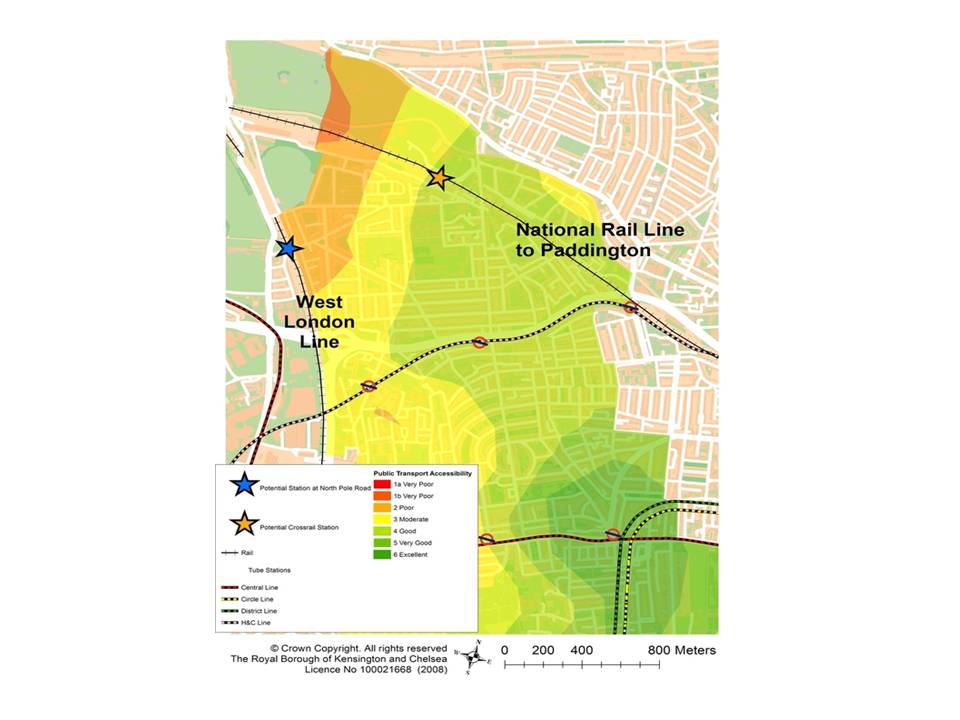
Public Transport Accessibility Levels in North Kensington and StQW area
5.1.3 In terms of public transport accessibility, the north-western part of RBKC has lower PTAL levels than in the rest of the borough. RBKC Core Strategy policies require any new development generating a high number of trips to be located in areas with public transport accessibility levels of 4 or above and where there is sufficient public transport capacity
5.1.4 The StQW area has PTAL scores of only 2 (poor) in the northern part of the neighbourhood and 3 (moderate) on the southern part. The road network in the area places huge pressures on the A219 Wood Lane/Scrubs Lane as the primary north south route. There is a severe pinchpoint at the Wood Lane/North Pole Road junction, as the only vehicle exit point to the west along a one mile length of Scrubs Lane/Wood Lane between the Harrow Road and the Holland Park roundabout.
North Pole and Wood Lane road junction
5.2.1 Long queues at this junction, causing traffic to back up (simultaneously) along Barlby Road, St Quintin Avenue, Bracewell Road, Brewster Gardens, and Latimer Road, are a regular feature of the day (mainly between 1600 and 1900 hours) and often at non-peak times. This situation has worsened significantly since the opening of the Westfield shopping centre and the additional traffic that this has created along Wood Lane. The developments at Imperial West, the St James site and the Stanhope scheme at the former BBC TV Centre will add to this congestion.
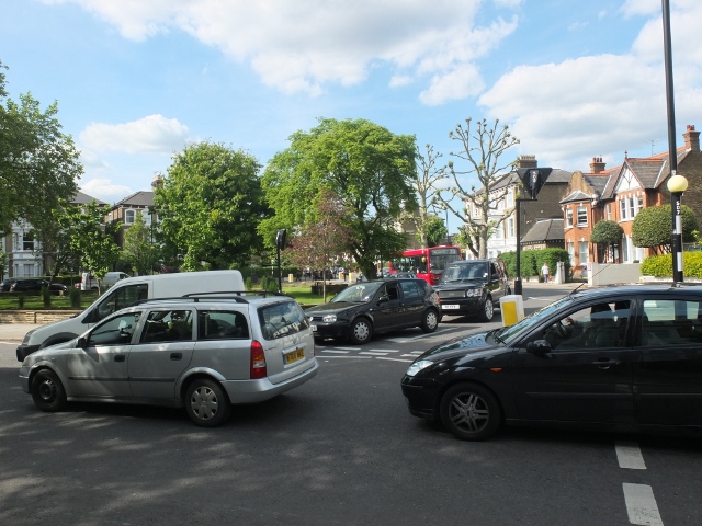
Traffic backing up in St Quint Avenue and Barlby Road, queuing to exit west from North Pole Road
5.2.2 A detailed Strategic Transport Study was carried out by TfL in 2011 as part of the White City Opportunity Area Planning Framework (GLA/LBHF). This noted the existing congestion at junctions on the A219 Wood Lane/Scrubs Lane and made forecasts for the impact of new developments in the Opportunity Area. In this document, and in the WCOAPF itself, various interventions and mitigation measures are proposed. These involve some junction re-design and encouragement of behavioural change to alternative transport modes.
5.2.3 The new Draft Local Plan for LBHF (public consultation recently closed) identifies the many traffic problems in the area but offers no radical or new solutions.
5.2.4 By London and national standards, the wards within which the StQW neighbourhood sits have average (but significant) levels of households with no access to a car or van (59.3% for the Dalgarno ward and 53.8% for St Helens compared with a borough average of 56%). Those residents who believe in the virtues of public transport, and who have no car as matter of choice, are frustrated to find that much of the Conservation Area is now blighted by queues of near stationary traffic at peak times.

Transport issues in and around the StQW neighbourhood
5.2.4 By London and national standards, the wards within which the StQW neighbourhood sits have average (but significant) levels of households with no access to a car or van (59.3% for the Dalgarno ward and 53.8% for St Helens compared with a borough average of 56%). Those residents who believe in the virtues of public transport, and who have no car as matter of choice, are frustrated to find that much of the Conservation Area is now blighted by queues of near stationary traffic at peak times.
Cycling
5.3.1 Kensington & Chelsea is not considered by London cyclists to be a leading Borough in terms of cycling policies (a comment from the London Cycling Campaign). The council committed in 2014 to devoting more attention to fulfilling its role in providing dedicated routes within the London Cycling Grid.
5.3.2 The Mayor of London and Transport for London have given the go-ahead to the construction of the Tower Hill to Paddington section of a proposed east/west segregated Cycle Super Highway. Plans for the full highway include using the section of the elevated Westway which crosses Kensington and Chelsea. It is not yet clear whether this section of the route will be approved, or whether alternative options (at ground level) come forward. Lack of access/egress to and from the section of the route within Keninsington & Chelsea is an issue.
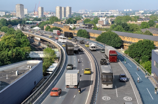
Westway section of proposed Cycle SuperHighway, looking westwards
5.3.3 Published plans for this ‘SuperHighway’ show the segregated route using one line of the eastbound carriageway, with cyclists ascending and descending via the ‘On’ ramp at the Westway elevated roundabout (on Wood Lane). The idea of adding heavy cycle traffic at this already congested junction has caused local concern, particularly in terms of that part of the traffic that will in future be heading northwards towards the transport interchange and new development at Old Oak. Hence this Plan proposes that the development site at 301 Latimer Road should be allocated for transport infrastructure use, as an entry/exit point to the Westway for cycle traffic.
Bus routes
5.4.1 Respondents to the StQW survey generally commented positively on the frequency and reliability on bus transport, probably reflecting a London-wide view that bus services have improved across the capital over the past decade. But there remain local concerns over existing bus routes, and in particular that there is no direct bus route to and from Kensington High Street.
5.4.2 Local ward councillors lobbied Transport for London in 2014 to vary bus route 452 to provide a direct link between Dalgarno Gardens and Notting Hill/High Street Kensington. TfL rejected the case for such a change, citing insufficient demand. TfL consider that routes 7 and 70 provide sufficient links for residents in the area wishing to travel south. The position will be reviewed as developments in the Kensal Opportunity Area come on-stream, but these remain many years away.
5.4.3 Meanwhile the Labour Group on the Council has promoted plans for a tram link from Ladbroke Grove (Sainsbury site) to Old Oak. This would be an alternative to a Crossrail station at Portobello North, a proposal for which RBKC continues to lobby.
5.4.4 The current bus services through the neighbourhood area are routed along Bramley Road/St Marks Road, and Barlby Road/North Pole Road. Bus stops are therefore some distance away from homes, especially for older people (including residents of Evelyn Fox sheltered housing in Kingsbridge Avenue). Bus stops are also some distance (a 6-8 minute walk) from the office buildings at the southern end of Latimer Road. This contributes to the high vacancy levels for office premises at this location.
5.4.5. It is difficult to see how these deficiencies in current routes could be mitigated. Routing buses down Oxford Gardens and along Latimer Road is a possible option but one that would be highly unwelcome to Oxford Gardens residents and would cause problems with the drop off and pick up of children at Oxford Gardens Primary School.
London Underground
5.5.1 Access to the Underground network from the StQW neighbourhood is relatively poor, the nearest station being Latimer Road (confusingly, not located on Latimer Road but 500m away on Bramley Road). This station is on the Hammersmith & City Line. While frequency of trains has improved since Circle Line trains began running to Hammersmith, this station does not give direct access to the West End.
5.5.2 Transport for London bases its catchment areas for Underground stations on a 900m radius and this distance is currently exceeded for most of the StQW neighbourhood area . The nearest Central Line station to the StQW neighbourhood (at White City) looks close on a map but in reality is a 12-20 minute walk for most StQW residents, and for the businesses in Latimer Road. This results from the physical barrier created by the West London railway line. Walking times to the Central Line, from much of the StQW neighbourhood, will reduce following the construction of the planned underpass between Latimer Road and Imperial West.
London Overground and Rail
5.6.1 There is no mainline railway station within easy reach of the StQW neighbourhood area. This one of the reasons why RBKC has made a strong case for a Crossrail station at Kensal/Portobello North, to improve PTAL levels for the north of the borough.
5.6.2 Transport for London and Network Rail consulted in late 2014 on 3 options for an Overground interchange at the proposed HS2/Crossrail hub at Old Oak. Option C emerged as that favoured by the Mayor of London. This involves a West London Line station at Hythe Road (off Scrubs Lane). While such a station would still be some 12-15 minutes’ walk from the northern part of the StQW neighbourhood, it would be closer than the existing Overground stations at Willesden Junction and Shepherds Bush Green.
5.6.3 In this wider context, the StQW Forum has been promoting the case for a second additional Overground station on the West London Line, to replace the original Wormwood Scrubs and St Quintin station originally located at Latimer Road (and subsequently North Pole Road) up until the 1940s. Lobbying for a replacement station at North Pole has been a RBKC Core Strategy/Local Plan commitment since 2011 (Policy CT2b).
5.6.4 The proposal in this Plan locates the proposed Overground station a few hundred metres to the south and adjacent to the planned pedestrian/cycle underpass between Imperial West and Latimer Road. This proposal is seen as a supportive modification to RBKC Policy Core Strategy Policy CT2b, and avoids the risks of resident objections (on noise grounds) to living next to station platforms, otherwise likely to come from those living in North Pole Road, Eynham Road, and Bracewell Road.
5.6.5 This location has also been promoted by the West London Line Group (a body with a history of successful lobbying for additional stations and capacity on this section of the London Overground). The West London Line Group has christened this location as ‘Western Circus’ and is continuing to petition Parliament on a on the proposal as part of the Hybrid HS2 Bill.
5.6.6 Transport for London argue that an Overground station at this location would not serve a sufficient catchment area and would not tie in well with current bus routes. It is not clear why a parallel case has been accepted for additional stations on the East London Line, at much shorter intervals between stations. Nor whether TfL are taking sufficient account of the scale of future development in White City East and at Old Oak.
5.6.7 TfL’s transformation of underused suburban rail links into the highly popular London Overground has seen passenger numbers rise by 400% since 2007 and the network become one of the most reliable and popular in the UK. RBKC and LBHF residents neighbouring the long gap in the line between Willesden junction and Shepherds Bush want to benefit from this connectivity and see traffic taken off Scrubs Lane/Wood Lane. A new station at Hythe Road is important for the future of the Old Oak area, but a station at Western Circus (a low cost location, on land already owned by TfL and with an underpass already funded) would serve a more immediate need.
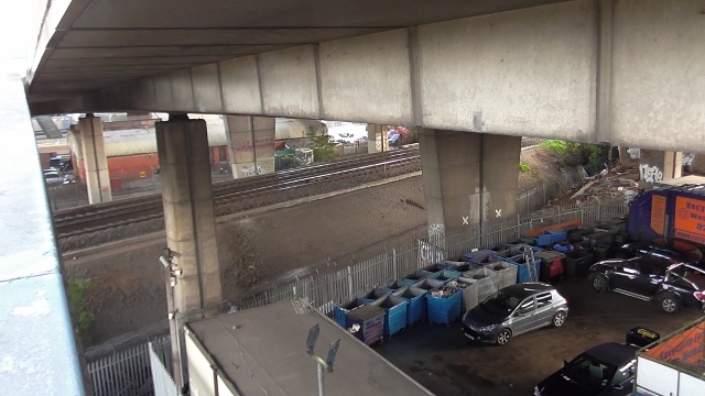
Suggested location for Westway Circus Overground station, beneath Westway elevated roundabout. The land on each side of the track is already in TfL ownership, and a new £4m underpass is due for construction to the immediate left of this image, allowing for a single ticket office. Costs of Imperial Wharf station (added to the line in 2009) were £7.8m, met by LBHF, RBKC, TfL and developers.
Pedestrian and cycle connectivity: the proposed underpass between Imperial West and Latimer Road
5.7.1 As acknowledged in the RBKC Core Strategy, pedestrian and cycle connectivity between the StQW part of North Kensington and adjoining neighbourhoods is poor. This was not the case when the St Quintin Estate was first laid out in the 19th century, at which time Latimer Road provided a well used north-south thoroughfare from North Pole Road to Holland Park Avenue.
5.7.2 The West London Line runs along the borough boundary and has for 150 years created a major barrier to east/west movement. This will change with the construction of the new underpass between Latimer Road and Imperial West, for which a planning application from Imperial College is awaiting decisions by RBKC and LBHF.
Latimer Road
5.7.1 As acknowledged in the RBKC Core Strategy, pedestrian and cycle connectivity between the StQW part of North Kensington and adjoining neighbourhoods is poor. This was not the case when the St Quintin Estate was first laid out in the 19th century, at which time Latimer Road provided a well used north-south thoroughfare from North Pole Road to Holland Park Avenue.
5.7.2 The West London Line runs along the borough boundary and has for 150 years created a major barrier to east/west movement. This will change with the construction of the new underpass between Latimer Road and Imperial West, for which a planning application from Imperial College is awaiting decisions by RBKC and LBHF.
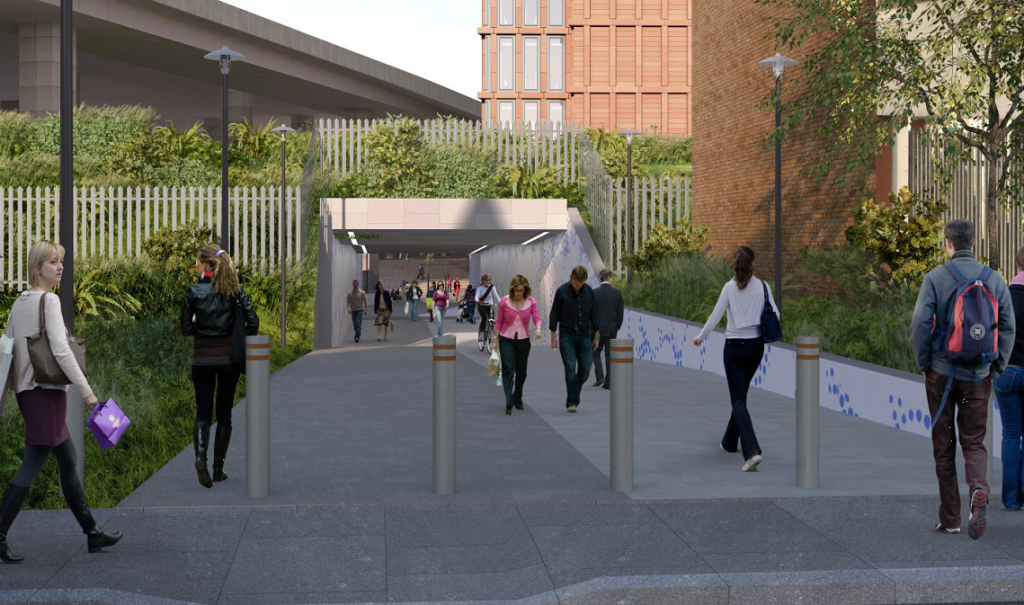
Image of Latimer Road entrance to proposed underpass. The £4m funding for the project forms one of the S106 ‘community benefits’ from the Imperial West development.
5.7.3 In terms of north/south connectivity through the StQW neighbourhood, St Helens Gardens and Bramley Road provide the main (and only) pedestrian cycle route through the area. Previous significant north/south through routes such as Latimer Road routes were cut off when the original local street pattern disappeared with the construction of the Westway. This had some advantages as well as disadvantages in that the current street pattern, in that the result has been to:
- concentrate more footfall onto St Helens Gardens and help to ensure the survival of this neighbourhood shopping parade.
- leave the streets running west of St Helens Gardens (comparatively) free of cars and cycle traffic and hence more peaceful.
5.7.4 Given this context for transport and traffic issues affecting the StQW neighbourhood, the proposed policies below are aimed primarily at influencing the decisions of TfL, RBKC and LB Hammersmith & Fulham. As stated above, one development site within the neighbourhood, at 301 Latimer Road, is proposed for allocation to transport infrastructure use. This piece of land (used only as a temporary car park, since the construction of the Westway) is the site of the proposed underpass between Latimer Road and Imperial West/Wood Lane. The entrance/exit will take up a third of the site. For the remaining part there are two possible transport infrastructure developments which could help significantly in reducing traffic congestion in this part of West London:
- ‘cycle lifts’ to allow cyclists to enter and exit the Westway stretch of the proposed east/west SuperHighway without having to negotiate the Wood Lane/A40 junction. Cyclists could then connect southwards to the planned cycle route through the Imperial West and St James developments to Westfield and Shepherds Bush, and northwards to Old Oak.
- a ticket office for a new Overground station at ‘Western Circus’. Immediate proximity to the Latimer Road/Imperial West underpass would allow for a single ticket office serving both platforms, and obviate the need for a footbridge across the tracks.
TRANSPORT AND TRAFFIC: DRAFT POLICY StQW 5
5a) to promote the case for a new Overground station on the West London Line (additional to any interchange at Old Oak) located beneath the Westway elevated roundabout and combined with the pedestrian/cycle underpass between 301 Latimer Road and Wood Lane (Imperial West).
Reasoned justification: this is a supportive modification to RBKC Core Strategy Policy CT2(b) and would improve PTAL levels and reduce traffic congestion within the StQW neighbourhood. RBKC Policy CT2(b) is ‘to promote the creation of a new station on the West London Line at North Pole Road’.
5b) to allocate the site at 301 Latimer Road for future transport infrastructure related to a) the Westway section of the east/west Cycle Superhighway and b) a potential ticket office and entrance to Overground platforms at an additional station on the West London Line at ‘Western Circus’.
Reasoned justification: this site has remained undeveloped since the late 1960s and its allocation for transport use in this Plan is designed to ensure that the opportunity to facilitate the east/west Cycle SuperHighway and/or an Overground Station at’ Western’ Circus is not lost. The land is ultimately owned by Transport for London, leased to RBKC for public amenity and community uses, and sub leased from the Council to the Westway Trust. Were transport infrastructure proposals not to come forward from TfL, StQW policies as at Section 8 of this Draft Plan would apply (i.e. allowing mixed use development). A 2006 planning approval for B1 office development on site was not pursued by Westway Trust due to lack of demand for office space at this location.
5c) In the context of RBKC policy CR1 on ‘street network’ to maintain the tranquillity of streets in the StQW neighbourhood area and resist any changes to the street network which will result in vehicular through traffic compromising amenity in the this part of the Oxford Gardens Conservation area.
Reasoned justification: there is concern, particularly from residents of Oxford Gardens and the surrounding streets, that the character of this part of the Oxford Gardens CA may be harmed at a future date by efforts to re-connect the historic north-south street beneath the Westway. Residents wish the StQW Plan to ensure that the application of RBKC Policy CR1 takes account of neighbourhood views when and if any such proposals come forward
5d) Where significant development is proposed within the StQW neighbourhood, to require that it be demonstrated that this will not result in increases in traffic congestion or on-street parking pressure, to an extent that would fail to preserve or enhance the character of the Oxford Gardens Conservation Area.
Reasoned justification: it is acknowledged that this is a near duplication of RBKC Policy CT1 b). Its proposed inclusion in the Plan is to signal to residents and businesses in the neighbourhood area that such a policy is in place borough-wide, and will be taken into account when development proposals are considered within the StQW neighbourhood.
ACTIONS
5i) to request that TfL undertakes regular monitoring of traffic delays at the junction of North Pole Road and the A219 Scrubs Lane/Wood Lane and pursues any mitigation measures to reduce current delays
5ii) to support the proposals for a pedestrian/cycle underpass between Latimer Road and Imperial West, subject to details of the design and 24/7 monitoring of CCTV cameras.
5iii) to support any further proposals to vary north/south bus routes, to provide a direct bus connection between St Marks Road/Barlby Road/North Pole Road and Kensington High Street.