In the Submission Version of the StQW Draft Plan, Annexe A includes a lengthy set of tables which do not convert well to web pages. This annexe covers THE RELATIONSHIP OF THE StQW PLAN TO THE NATIONAL PLANNING POLICY FRAMEWORK, AND SUSTAINABILITY APPRAISAL OF THE PLAN. If you wish to read this Annexe please download the full PDF version of the StQW Plan at this link
The remaining annexes cover the three topics below and are reproduced on this web page:
ANNEXE B RBKC CONSERVATION POLICIES, ARTICLE 4 DIRECTIONS, AND THEIR RELATIONSHIP WITH NATIONAL RULES ON PERMITTED DEVELOPMENT
ANNEXE C SITES PROPOSED IN THIS DRAFT PLAN FOR DESIGNATION AS LOCAL GREEN SPACE
ANNEXE D COMMUNITY INFRASTRUCTURE LEVY
RBKC CONSERVATION POLICIES, ARTICLE 4 DIRECTIONS, AND THEIR RELATIONSHIP WITH NATIONAL RULES ON PERMITTED DEVELOPMENT
What is permitted development?
B.1.1 Building owners can make certain minor changes to their property under ‘Permitted Development Rights’. These are national planning rights, granted by Parliament and overriding what individual local authorities allow. These rights do not apply to flats or maisonettes. An explanation of these rights can be found at www.planningportal.gov.uk.
B.1.2 Where changes or alterations fall within Planning Development Rights, planning permission is not required (although approval under Building Regulations may be). Building owners may wish to apply to the local planning authority (i.e. RBKC) for a Certificate of Permitted Development. This provides assurance to a subsequent purchaser that the works undertaken do not contravene planning legislation.
B.1.3 Local Planning Authorities can remove specific Permitted Development Rights through the use of Article 4 Directions. Planning permission is then required. This common in relation to Conservation Areas, but Article 4 Directions can also be used elsewhere (such as removing the permitted development right for change of use from a pub).
B.1.4 RBKC has introduced many separate Article 4 Directions over the years. Those relevant within the StQW neighbourhood have been in place since the 1980s and are Directions numbered 46/62 (dating from 1977 and removing rights to alter roofs and front facades) and No.69 (dating from 1997 and removing rights to install hard surfaces in front gardens). These Directions apply only to specified streets, or parts of streets, and not across the whole of the Oxford Gardens Conservation Area.
B.1.5 Hence it is not straightforward to establish what sort of alterations require planning permission, and what do not. The Government’s Planning Portal at http://www.planningportal.gov.uk/ is the most authoritative source of information, and the RBKC website provides a street by street list of which Article 4 Directions apply.
B.1.6 The Article 4 Directions in force in the Oxford Gardens CA cover the following works or alterations:
Direction 46/62 removes Permitted Development Rights on
- ‘alterations, improvements and extension to any part of those elevations of a dwelling house which front onto a highway, being development comprised within Class I(i).’
- ‘alterations, improvements and extensions to any part of the roof of the original dwelling house’, being development comprised within Class I(i).’
The specific streets and part streets covered by this Direction are as follows:
Balliol Road Nos 1-25 odd 2-26 even inclusive
Finstock Road Nos 3-41 odd and 2-42 even inclusive
Highlever Road Nos 1-127 odd, 2-88 even inclusive
Kelfield Gardens Nos 15-21 odd, 22-33 odd, 2-46 even inclusive
Kingsbridge Road 1-23 odd inclusive
Oxford Gardens Nos 135-185 odd, 122-174 even inclusive
St Helens Gardens 21-51 odd inclusive
St Quintin Avenue Nos 1-31 odd inclusive
Wallingford Avenue Nos 1-69 odd, 2-74 even inclusive
Direction 69 removes Permitted Development Rights on ‘any provision of or extension to a hard surface for any purpose, which fronts a highway of any property in wholly residential use which is, or may become a dwelling house being comprised within Class F(i)
This Direction covers properties at the following addresses:
Barlby Road 1-65 odd, 2-34 even
Bassett Road 1-63 odd, 2-66 even
Cambridge Gardens 31-41 odd, 61-107 odd, 111-121 odd, 6-54 even, 60-112 even
Dalgarno Gardens 58-116 even
Highlever Road 1-127 odd, 131-143 odd, 147-173 odd, 2-104 even, 108-160 even
Oxford Gardens 5-109 odd, 38-46 even, 50-112 even
St Charles Square 43-69 odd, 2-38 even
St Helens Gardens 21-59 odd, 54-62 even
St Lawrence Terrace 1-25 odd, 2-24 even
St Marks Road 77-101 odd, 2-24 even
St Quintin Avenue 1-33 odd, 37-67 odd, 71-83 odd, 2-14 even, 46-80 even
St Quintin Gardens 2-8 consec.
RBKC Conservation and Design Policies
B.2.1 Chapter 34 of the Council’s 2010 Core Strategy/Local Plan is called ‘Renewing the Legacy’ and sets out conservation and design policies.
B.2.2 The Council has completed an exercise of consolidating former ‘saved’ UDP policies and the 2010 Core Strategy policies in a ‘Partial Review’ of the Core Strategy. The new policies were adopted in December 2014 and can be found under Conservation and Design on the RBKC website.
The Oxford Gardens Conservation Area Policy Statement (CAPS)
B.3.1 This document was first published in 1977 and updated in 1990. It can be found on the RBKC website alongside similar documents for other Conservation Areas.
B.3.2 The document sets out the history of the Conservation Area, with a commentary on aspects that need to be ‘preserved or enhanced’ to protect its ‘character’. These are the terms used in the Planning (Listed Buildings and Conservation Areas) Act 1990, which sets the framework for conservation legislation.
B.3.3 The Oxford Gardens CAPS document continues to be referred to in planning officer reports recommending approval or refusal to alterations to properties within the Conservation Area.
Conservation Area Appraisals (CAA)
B.4.1 The Council has been aware that many of its CAPS documents have become outdated and is undertaking a programme of preparing new style documents, called Conservation Area Appraisals.
B.4.2 These new Conservation Area Appraisals will not set or change RBKC policy. Policy on conservation and design is set by the RBKC Local Plan. The CAAs will form an evidence base setting out what contributes to the character or appearance of the conservation area.
B.4.3 The stated aims of the new-style Conservation Area Appraisals are to:
- define the historic and architectural character and appearance of the area
- identify what is worthy of conservation
- raise public interest and awareness of the objectives of the conservation area designation
- encourage public involvement in the protection of the area
How will the new CAA for Oxford Gardens relate to the StQW Neighbourhood Plan?
B.5.1 The Oxford Gardens Conservation Area covers a wider area than the StQW neighbourhood (extending east to Ladbroke Grove) so the conservation policies in the StQW Plan will apply to only part of the CA.
B.5.2 Subject to support in a referendum, the conservation proposals in the StQW Neighbourhood Plan will be ‘policy’ rather than ‘policy guidance’. This is because neighbourhood plans (once adopted by the Council) form a statutory part of the Local Development Plan. So the StQW policies will be a material consideration in deciding planning applications. This is why it is important that the proposals in the StQW Plan are widely understood within the neighbourhood, and are supported by a majority at the referendum stage.
Enforcement of conservation policies
B.6.1 Partly because of the complexities of the planning system, and partly because property owners may make assumptions on what works can be undertaken without planning permission, it is common for local planning authorities to take enforcement action on unpermitted alterations or conversion works.
B.6.2 RBKC regularly pursues enforcement issues in conservation areas, and has a larger and more effective team than in most London Boroughs. More details are available under ‘enforcement’ on the RBKC website. Ignoring planning requirements or Article 4 Directions can prove an expensive business, if e.g. roof alterations are required to be removed or parts of the original property reinstated.
B.6.3 The St Helens Residents Association has since 2008 routinely monitored the weekly list of planning applications in the StQW neighbourhood, and will submit comments to the Council where the Association feels that proposals contravene conservation area policies. The same approach will be followed as and when the StQW Neighbourhood Plan is adopted. It is in the collective interests of everyone in the area to ensure that the heritage value (and related property value) of houses and buildings in the area is maintained.
B.6.4 In certain limited respects, and particularly in relation to the rear of houses, the proposed StQW conservation policies involve some relaxation of current RBKC borough-wide policies. It is hoped that this will reduce the number of occasions when house-owners feel aggrieved, or treated unfairly, as a result of refusal of an application which appears similar to one approved in the same or a neighbouring street.
B.6.5 It is hoped also to reduce the number of appeals to the Planning Inspectorate, from house-owners in the neighbourhood. Out of 26 planning appeals on houses in the StQW area, 10 have been allowed by Planning Inspectors since 2003. This suggests that certain RBKC policies are considered by the Planning Inspectorate to be over-restrictive in relation to the types of house in this neighbourhood.
Applying for planning permission
B.7.1 As this Annexe has sought to explain, it is not a simple matter for property owners in the StQW neighbourhood to know whether or not a planning application is required for what might seem to be a minor alteration. Nor can owners always foresee whether approval from the Council will be forthcoming.
B.7.2 The policies proposed in this Draft Plan seek to fine tune some RBKC policies, to ensure that their application in the StQW neighbourhood becomes more consistent.
B.7.3 The StQW Forum will be monitoring closely how the Council determine planning applications once the StQW Plan is in place. In the meantime, the Council has suggested a series of points of which applicants for planning permission should be aware, in making applications in respect of roof alterations in particular:
- Rooflights should be avoided on roof slopes facing the street (as per StQW proposed Policy 2c)
- Side roof slopes should not be extended. In particular ends of terrace are unlikely to have an appropriate style of roof on which to add an extension
- Development close to the edges of the roof should be avoided (i.e. keep rear dormers away from the ridge, eaves and party walls)
- Extensions on the roof of the ‘outrigger’/original rear addition will be resisted
- Roof extensions should not cut into or cause the ‘outrigger’ to be altered externally
- Care should be taken not to use roof vents that are visible on the roof slope.
B.7.4 In relation to other alterations, the Council is likely to be supportive of applications
- which use traditional materials in keeping with the character of the conservation area, particularly on any part of the house visible from the street (e.g. painted timber, lead, slate/tile, etc)
- where windows facing the street are in keeping with the original windows of the host house in terms of materials, finish and details
- which reinstate original detailing, such as chimney pots and filials (ornamentation) on roofs
B.7.5 For the Council, the overriding objective is for houses in a terrace to have a uniform design that complements that specific terrace. The StQW Forum supports this principle, provided that home-owners are able to make reasonable alterations to their properties to reflect contemporary lifestyles.
Design Guidance
B.8.1 The previous CAPS documents (now being replaced) included design guidance on rear dormers and front boundary walls. These guidelines gave examples of what was likely to be acceptable to the Council, in instances where planning permission for alterations is required. The new CAA documents will not include this form of advice.
B.8.2 This annexe to the StQW Draft Plan attempts to provide similar guidance in the pointers in paragraphs B.7.3 and B.7.4 and in the photographs included in Section 2 of the plan on Conservation. This advice should not be assumed as definitive, as it will be RBKC planning officers and not the StQW Forum, which will be making recommendations and decisions on planning applications. House-owners should approach the Council’s Planning Department for guidance in instances where the permissibility of alterations to properties is uncertain.
ANNEXE C SITES PROPOSED IN THIS DRAFT PLAN FOR DESIGNATION AS LOCAL GREEN SPACE
C.1.1 The designation of pieces of land as Local Green Space is a relatively new feature of the English planning system. Paragraph 76 of the 2012 National Planning Policy Framework states:
‘Local communities through local and neighbourhood plans should be able to identify for special protection green areas of particular importance to them. By designating land as Local Green Space local communities will be able to rule out new development other than in very special circumstances. Identifying land as Local Green Space should therefore be consistent with the local planning of sustainable development and complement investment in sufficient homes, jobs and other essential services. Local Green Spaces should only be designated when a plan is prepared or reviewed, and be capable of enduring beyond the end of the plan period’.
C.1.2 Paragraph 77 sets out the criteria for designation of Local Green Space, as follows:
The Local Green Space designation will not be appropriate for most green areas or open space. The designation should only be used:
- where the green space is in reasonably close proximity to the community it serves;
- where the green area is demonstrably special to a local community and holds a particular local significance, for example because of its beauty, historic significance, recreational value (including as a playing field), tranquillity or richness of its wildlife; and
- where the green area concerned is local in character and is not an extensive tract of land.
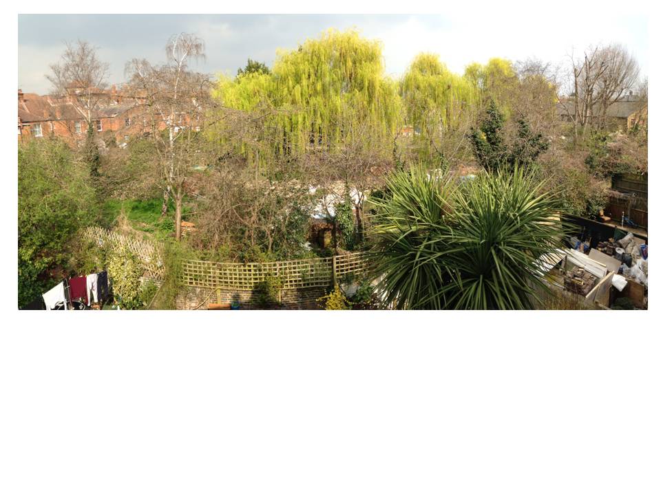
C.1.3 In this Draft Plan, the three surviving ‘backlands’ in the St Quintin Estate are proposed for Local Green Space designation (StQW Draft Policy 4a in Section 4 above). These pieces of land share a number of common characteristics.
- all three date from the original layout of the St Quintin Estate, when planned by the St Quintin family in the late 19th century, and were intended for communal sporting and recreational use.
- all three have been used for varying lengths of time for this original intended purpose.
- all three are privately owned land. None has ever had general public access.
- their current amenity value, in planning terms, relates mainly to the views and sense of tranquillity that they provide to the surrounding terraced housing. Views of these pieces of land from public places are limited.
- as green spaces, and ‘green lungs’ they are also important to the bio-diversity of the Borough, RBKC being one of the most densely developed areas in Europe and one with high levels of air pollution.
- all three (in the view of the StQW Forum) remain as land which has not been ‘previously developed’. They are therefore defined as ‘greenfield’ rather than ‘brownfield’ sites in terms of policies within the National Planning Policy Framework. This is a feature unusual for private land so close to central London.
C.1.4 The shared history of these backlands stems from the origins of the StQW part of the St Quintin Estate.
What had started as a speculative business partnership between Charles Henry Blake and Colonel Matthew Chitty Downs St Quintin turned into the development of a part of London by a ground landlord who was socially and environmentally aware. While Blake was a notorious Victorian property speculator, exploiting the new railway access to North Kensington and building housing of poor quality, Colonel St Quintin and W H St Quintin exercised close control over the design and building of the St Quintin Estate.
C.1.5 William Herbert St Quintin had a long career in local politics, being a JP from 1875 through to his death and an alderman from the time of the formation of the Council in 1889. He was High Sheriff of Yorkshire in 1899 and Deputy Lieutenant of the East Riding. He was a naturalist interested in hunting, fishing, falconry, ornithology and entomology, and travelled in Europe as a young man. Unlike Blake, he was not solely concerned with speculative development that brought quick profits.
C.1.6 As noted in the 1990 RBKC Oxford Gardens CAPS document, the buildings in ‘District C’ of the Conservation Area are ‘fine examples of early twentieth century terraces’. ‘Buildings are farther apart than elsewhere in the Conservation Area. There generally more than 22 metres between building lines and this, together with the limited height of the houses, results in streets of surprisingly generous proportions. Space behind and at the corner of terraces is also generous, and the consequent suburban openness is very important to the character and appearance of the area’.
C.1.7 The backlands of the St Quintin Estate are not accidents or leftover spaces from speculative building, they are a planned part of the amenity and openness of the area which a Victorian ground landlord recognised as being important to the quality of life of its residents. They are part of the heritage of the neighbourhood.
C.1.8 All three pieces of land proposed for designation as Local Green Space would seem to meet clearly the first and third of the NPPF criteria quoted above in paragraph C.1.2. The main issues for an Examiner of the StQW Plan will be in relation to the second criteria. Ownership is not one of the criteria for designation and private land has been designated as Local Green Space via a number of local and neighbourhood plans since this procedure was introduced in 2012.
The St Quintin backlands as originally laid out
West London Bowling Club
C.2.1 This 0.46 hectare piece of land has been in continuous use as a sporting club since the estate was first developed from farmland by the St Quintin family. Occupied by a bowling green and club house, the freehold of the land was sold in 1930 by W H St Quintin (near the end of his life) to the West London Bowling Club Ltd, a private limited company with share capital. A covenant restricts use to ‘a Bowling Ground or Recreation Ground, to be used in such a manner not to cause any nuisance or annoyance to the householders abutting the said piece of land’. The same covenant restricts buildings on the land to a pavilion for a club or recreation ground.
C.2.2 The site is not open to the general public other than by invitation of Club members. The Club now has a membership of over 100 local residents, having widened its range of activities under the direction of a new management committee. The bowling green, and adjoining planted areas, are overlooked by 65 houses in the terraces of Barlby Road, Highlever Road, and St Quintin Avenue
C.2.3 The StQW Forum considers that this piece of land meets the criteria for Local Green Space on the following grounds
- it lies within the community it serves;
- it is local in character and not an extensive tract of land
- it forms part of the historic plan form and setting of the St Quintin Estate (see 2.1.6 to 2.1.9 above)
- the space makes an important contribution to the character, townscape, and setting of the surrounding terraces
- it has recreational value, as a bowling club with a long history
- it provides visual amenity and tranquillity to the households which overlook it (there have been some issues in the past of noise nuisance to neighbours, but new management of the bowling club has resolved these).
- the bowling green and surrounding gardens are attractive, and make an important contribution to the character, townscape, and setting of the surrounding
C.2.4. As mentioned in Section 4 of this Plan, the land and present pavilion building are a registered Community Asset. Looking to the long-term future of the land, the Directors of WLBC Ltd supported the application for Community Asset registration, and also support the proposed designation of the site as Local Green Space. There is good reason to suppose that, with this designation, the land will remain in communal recreational use.
Land behind Kelfield Gardens (former Kelfield Sports Club)
C.3.1 The freehold of this second piece of backland (0.21 hectares) is owned by the Trustees for Methodist Church Purposes, i.e. the Methodist Church. Disposition is subject to Charity Commission requirements. This ownership dates from 1923. A 1979 statement from the Methodist Church says that the land was ‘acquired from’ the St Quintin family. Other correspondence from local residents suggests that the land was gifted to the church.
C.3.2 As with the Bowling Club land, use of the site is covered by a covenant. In this case use is restricted to ‘an ornamental garden or as a lawn tennis or croquet ground or bowling green for the use enjoyment and recreation of the members and friends of the Lancaster Road, Wesleyan Church War Memorial Athletic Club or other Athletic Club’.
C.3.3 The land was known for several decades as the Kelfield Sports Ground and between the wars was used for tennis and bowls. During the 1970s a playgroup began operating from a small building off Kelfield Gardens on the eastern side of the site.
C.3.4 In January 1979, the Methodist Church sought planning permission for a scheme for 27 sheltered flats and a warden’s flat. Following public meetings convened by the RBKC, and a local campaign, this application was refused. Grounds for refusal were contravention of policies in the Leisure and Recreation chapter of the Draft District Plan, detriment to the Conservation Area, and inadequate vehicular access to the site. The RBKC committee report described the site as ‘one of the open areas which lies at the rear of houses of the St Quintin Estate and is a feature which contributes greatly to the character of the Conservation Area’.
C.3.5 Shortly after this decision (15 February 1979) the Council adopted the Oxford Gardens CAPS. Public opposition to building on the Kelfield sports ground no doubt contributed to the policy statement in this document that proposals to develop the St Quintin backland sites for housing ‘will not be permitted’.
C.3.6 The RBKC refusal to the sheltered housing scheme was appealed by the landowners, and the appeal dismissed in July 1980.
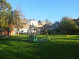
Backland site owned by Methodist Church, behind Kelfield Gardens
C.3.7 Since then the land has remained as an area of green space, with mature trees. The New Studio Pre-School occupies a small building (converted from the former sports pavilion) off Kelfield Mews. Part of the backland is used by this playgroup, and has outdoor play equipment. The remainder of the site is fenced off as informal green space. No further planning applications have been submitted in relation to the site.
C.3.8 The StQW Forum considers that this piece of land meets the criteria for Local Green Space on the following grounds
- it lies within the community it serves;
- it is local in character and not an extensive tract of land
- it forms part of the historic plan form and setting of the St Quintin Estate (see 2.1.6 to 2.1.9 above)
- it has recreational value for young children attending the New Studio Pre-School
- it provides visual amenity and tranquillity to the 40 households which overlook it
- it forms part of the historic plan form and setting of the St Quintin Estate (see 2.1.6 to 2.1.9 above)
- the space makes an important contribution to the character, townscape, and setting of the surrounding terraces.
- the land has never been developed and a previous planning application for development has been rejected at appeal.
Land at Nursery Lane
C.4.1 Paragraph 4.3 of this Plan summarises the planning history of the Nursery Lane site. Along with other backlands planned as an integral part of the St Quintin Estate, this site was also originally used for sporting and recreational purposes. The Ashfield Tennis Club operated with hard courts on the southern part of the site, and grass courts on the northern part, up until the 1940s.
C.4.2 The land has remained in the continuous ownership of the St Quintin family and the Legard family (who inherited the assets of the St Quintin family in the 1950s).
C.4.3 A 1931 aerial photograph shows two buildings on the site. Local residents who have lived in the StQW neighbourhood all their lives advise that both were wooden structures. The southern building was used as a clubhouse (a fairly primitive one by all accounts, with no flushing toilet). The northern building was used to house mowers and equipment to maintain the tennis courts.
C.4.4. The tennis club lost members following the outbreak of the 1940-45 war and the tennis courts suffered bomb damage. The whole of the northern part of the site was then used as allotments during and after the war. In 1952 the land was offered to the Council by the owners as a public park, but the offer was declined on grounds of resultant maintenance costs falling on the local authority. Permission was granted to a Mr Green by the London County Council for use of part of the site for ‘storage of plant and materials in connection with a garden contractors business‘, with advice that this was an agricultural use not requiring planning permission. The northern part of the site was used by Latymer School as playing fields during the 1950s and early 1960s.
C.4.5 In 1959 planning permission was granted the erection of a ‘sectional timber hut’ on the playing field, for use as an equipment store and changing room, as part of use by Latymer School as playing fields. The Borough notified Mr Green that his temporary permission had expired and a re-application for similar use was approved as permitted development (agricultural use). Highgate Nurseries (with the same address as Clifton Nurseries) took on the garden nursery business.
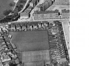
Aerial view of the backland in 1931, showing the Ashfield Tennis Club (from the Britain from the Air series’
C.4.6 In 1970 the Council submitted its own application for 40 warden controlled flats, plus additional family housing at total density of approx 136p.p.a. This proposal was in support of ‘the Council’s slum clearance programme in North Kensington’. Highgate Nurseries objected and the subsequent planning appeal ruled against the Council’s proposed housing development. The Inspector concluded that old peoples flats could be built on a 3/4 acre southern part of the site, with the garden nursery remaining in place on the northern acre and a half. The present Nursery Lane Sheltered Housing development was granted planning approval in 1977.
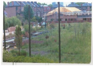
The land at Nursery Lane in the late 1970s, when the sheltered housing was being built on the southern part of the original site. The tall fence posts remain from the period when the northern part was used by Latymer School as playing fields.
C.4.7 In 1981, the Legard family submitted a planning application for 23 houses (4 and 5 person). This was refused by RBKC on grounds of resisting loss of open space, public and private, and detriment to the Conservation Area. This refusal was appealed and a further planning inquiry held in 1982. The Planning Inspector dismissed the appeal.
C.4.8 The arguments put forward by the Council at the 1982 hearing are relevant today, in that the Oxford Gardens Conservation Policy Statement had been adopted 3 years previously, and has remained in place and in use as a policy guidance in planning decisions until today. Very little has changed in relation to the Nursery Lane land and its surroundings, in the intervening period.
C.4.9 The Borough Planning Officer explained in a written statement to the 1982 inquiry ‘the Conservation Area Policy Statement identifies the site as one of three similar back-land area of open space within the St Quintin Estate, and as one particularly vulnerable to pressures for development. Such spaces contribute to the small-scale atmosphere of the area by separating the main housing terraces, and their permanent development “precludes their ever being used for recreation or leisure.. this land should preferably be retained in open space use”.
C.4.10 His statement concludes: it is considered that the proposed development results in an unacceptable loss of outlook and open space, amenity and it is detrimental to the traditional character of the area. The proposal makes no contribution to the preservation and enhancement of the Conservation Area, and is strongly opposed by the local community’.
C.4.11 This recognition of the similarity between the three St Quintin backland sites, and their contribution to the area, is recognised in the Oxford Gardens CAPS 1 (see C.1.7) and in the 1990 CAPS ‘policy statement’ that housing development on these pieces of land would not be allowed.
C.4.12 The Planning Inspector at the 1982 inquiry, in dismissing the appeal on the proposed housing development, commented ‘I found the backland open spaces a feature of this part of the St Quintin/Oxford Gardens Conservation Area’.
C.4.13 Since the 1982 planning inquiry, no further planning applications were put forward for the Nursery Lane site until May 2015. This piece of land is shown alongside the other two surviving St Quintin backlands as a ‘Garden Square and other Green Space‘ on the Bio-diversity map at page 441 of the 2010 Core Strategy/Local Plan. The three pieces of land are shown in the same way on the map on page 54 of the RBKC Core Strategy Partial Review Miscellaneous Matters publication, adopted by the Council in December 2014. This suggests that the Council’s view of the land as green open space has not changed, and that its environmental and bio-diversity value continues to be recognised.
C.4.14 The StQW Forum wrote in December 2013 to the Legard family, asking their intentions for the land. No response was received. The site was marketed by Knight Frank as a ‘residential development opportunity’ in April 2014. Proposals for a development of 21 four bedroomed houses were exhibited to local residents in December 2014. A planning application for a development of 20 such houses was submitted in May 2015.
Is the site Previously Developed Land?
C.4.15 While there is little argument that the West London Bowling Club and the Kelfield backland fall outside the NPPF definition of Previously Developed Land, the position on the Nursery Lane site is contested. Consultants acting for the Legard family and for a potential developer of the site have both submitted representations, in response to the Consultation Version of the StQW Draft Plan, arguing that the site ‘has features of Previously Developed Land’. The RBKC Planning Department has also recently expressed this view (RBKC letter from Head of Forward Planning 24th February 2015).
C.4.16 The Forum contends that the site is not PDL and is therefore greenfield rather than brownfield land for the following reasons:
- a) planning permissions granted in relation to the site have been for horticultural or agricultural uses, and for no other uses.
- b) any buildings or structures on the site, at any time, have been limited to those relating to use as a sports ground (timber buildings for Ashfeld Tennis Club, sectional wooden hut as changing rooms for Latymer School) or for agricultural/horticultural use (wooden messroom, glasshouses, and steel containers granted permission to be ‘placed on the land’, for Clifton Nurseries). These types of use and of building are specifically referred to in the NPPF definition of Previously Developed Land as not constituting ‘development’.
- c) the fact that there is some hard surfacing and an access track within the site does not mean that the site falls within the NPPF definition of PDL.
C.4.17 ‘Previously Developed Land’ is defined in the National Planning Policy Framework as follows:
‘Land which is or was occupied by a permanent structure, including the curtilage of the developed land (although it should not be assumed that the whole of the curtilage should be developed) and any associated fixed surface infrastructure. This excludes: land that is or has been occupied by agricultural or forestry buildings; land that has been developed for minerals extraction or waste disposal by landfill purposes where provision for restoration has been made through development control procedures; land in built-up areas such as private residential gardens, parks, recreation grounds and allotments; and land that was previously-developed but where the remains of the permanent structure or fixed surface structure have blended into the landscape in the process of time.’
The conservation and heritage value of the site
C.4.18 The Oxford Gardens Conservation Area Proposals Statement (CAPS) comments on the importance of the ‘suburban openness’ of ‘District C’ within the Oxford Gardens CA, as laid out by W H St Quintin (see paragraph 2.1.6. above). The CAPS concludes that the Conservation Area is ‘an extremely pleasant part of North Kensington’. It is clear from these statements and from the Council’s evidence to the 1982 planning inquiry that RBKC has over a long period considered the Nursery Lane land to have significant conservation value. The 1990 CAPS document includes specific policy guidance that the three surviving backland sites should not be developed for housing.
C.4.19 Negative views of the conservation value of the land have recently been expressed by two sets of planning consultants acting for the owners and potential developer of the land at Nursery Lane, in representations on the Consultation Version of the StQW Plan. These include the claim from Rolfe Judd Planning that the site ‘detracts from the area’s intrinsic qualities’.
C.4.20 The Council has a statutory duty under Section 72 of the Planning (Listed Buildings and Conservation Areas) Act 1990 to have regard to preserving or enhancing conservation areas. 1990 was the year in which the Council revised and re-adopted the Oxford Gardens CAPS document. The legislative context for what constitutes positive or negative conservation assets has not changed materially since. There have been no significant physical changes to the layout and aspect of the southern part of the Nursery Lane site since RBKC gave evidence at the 1982 appeal hearing. The appearance and amenity value of the Nursery Lane site in terms of its setting within the neighbouring terraces, and the outlook that it offers to surrounding buildings, remains the same today as it was then.
C.4.21 The StQW Forum considers all three backlands to make an important positive contribution to the conservation area, and that their long-term protection from development should be considered in this context. Apart from the amenity value these pieces of land give to their immediate neighbours, their importance in conservation terms relates to ‘the still-visible effects/impact of the area’s historic development on its plan form, character and architectural style and social/historic associations’ (English Heritage Understanding Place: Conservation Area Designation, Appraisal and Management, Revision Note June 2012).
Bio-diversity and Wildlife
C.4.22 One of the special qualities of the land at Nursery Lane is the contribution made by its trees and its wildlife. The key arboricultural features of the site are the two rows of trees within the centre (a row of Leyland cypress running east-west and a row of 10 mature weeping willows running north-south) along with a further group of three willows adjacent to the eastern boundary.
C.4.23 A row of mature weeping willows is a rare feature in Central London. These trees were planted by Clifton Nurseries in the late 1970s, it is thought as part of efforts to drain the often waterlogged site which lies above the line of Counters Creek – one of London’s ‘lost’ underground rivers.
C.4.24 RBKC Core Strategy Policy CR6 on Trees and Landscape requires the protection of existing trees, and CR6(b) resists development which results in the damage or loss of trees of townscape or amenity value. The Council’s Tree Strategy makes clear the importance to the Borough of mature trees in public parks, garden squares, and private open spaces.
C.4.25 The Nursery Lane site is a few hundred yards from the Wormwood Scrubs Nature Reserve (a Reserve across the borough boundary in LBHF, designated in 2002). Nursery Lane shares several of the rare bird populations, bats, butterflies, and mammals of this Sanctuary (where over 100 species of birds have been spotted). Wildlife and birds seen on the Nursery Lane site include Pipperelle bats, Stag Beetles, Death Head Moth, Giant Hawks Moth, Red Underwing, Green Woodpecker, Greater Spotted Woodpecker, Gold Crests, Coal Tits, Long Tail Tits, Greenfinches, Spotted Fly Catchers, Whitethroats, Wrens.
C.4.26 ‘Tranquillity or richness of wildlife’ form part of the criteria for designation of Local Green Space, as defined in the National Planning Policy Framework.
Conclusion
C.4.27 The StQW Forum considers that land at Nursery Lane meets the criteria for Local Green Space on the following grounds:
- it lies within the community it serves.
- it is local in character and not an extensive tract of land.
- it forms part of the historic plan form and setting of the St Quintin Estate (see 2.1.6 to 2.1.9 above).
- it provides visual amenity and tranquillity to the 42 houses and 35 sheltered flats which back onto the site.
- the space makes an important contribution to the character, townscape, and setting of the surrounding terraces.
- the mature weeping willows on the site, when in leaf, are of great beauty.
- the above are reasons why the major part of the original backland has never been developed and two previous planning applications for development of this part of the site have been refused at appeal.
C.4.28 In considering proposals for designation as Local Green Space, an Examiner will clearly wish to give consideration to the NPPF requirement that ‘Identifying land as Local Green Space should therefore be consistent with the local planning of sustainable development and complement investment in sufficient homes, jobs and other essential services’.
C.4.29 In relation to the demand for ‘sufficient homes’ it is acknowledged that RBKC has fallen behind in delivering its housing targets. But to the east of the Nursery Lane site lies the Kensal Opportunity Area, in which the Council plans to deliver 2,000-3,500 new homes. And nearby to the west is the Old Oak area, in which the Mayor of London and OPDC propose the building of 24,000 new homes.
C.4.30 In terms of ‘sustainable development’, the allocation for housing use of pieces of backland that remain to this day undeveloped and ‘greenfield’ land, seems to the StQW Forum to make no sense and to be contrary to the intentions of the NPPF. This land, after surviving 200 years of London’s development, would be lost for good as undeveloped land. Section 10 of the StQW Draft Plan identifies three other brownfield sites, more suited for housing development, which would make a good contribution to the Borough’s housing targets. Of the housing sites proposed, the largest number of new housing units could be provided in Latimer Road, a location not currently included in RBKC assessments of a 5 year housing supply.
C.4.31 Designation of all three St Quintin backlands as Local Green Space would provide planning certainty, for the duration of the StQW Plan and in all likelihood beyond, on these pieces of land. It is this outcome that local residents and the StQW Forum seek.
Potential future use of the land at Nursery Lane
C.4.32 Were the site to be designated as Local Green Space, while remaining private land in the ownership of the Legard family, the question clearly arises as to what uses it would be put?
C.4.33 The StQW Forum considers that there are several potential uses of the land which would be viable and appropriate, once the ‘hope value’ of the site as a ‘residential development opportunity’ ceases to be a factor. Land Registry information indicates that no sale of land by the Legard family has yet been completed. The Legards themselves inherited rather than acquired the land. Hence designation of the site as Local Green Space would not appear to impact severely on the private rights of the landowners, other than in terms of a lost opportunity to reap major capital gain from permission for a change of use from agricultural to housing land.
C.4.34 The potential future uses for the land, as perceived by the StQW Forum, include the following, several of which could be combined:
- continued use as a commercial nursery garden
- use by RBKC within its Royal Borough Environment Project (this includes a Community Kitchen Garden scheme with nearly 50 sites in operation across Kensington & Chelsea).
- use as a RBKC sponsored ‘community market garden’ (see below)
- a new ‘garden square’ to add to the over 100 such communal squares which are a particular feature of RBKC and which are managed by garden committees with the Council collecting a small precept.
- well designed outdoor space for the residents of the sheltered housing on the southern part of the original site, thereby allowing for more intensive development of this part of the site as Extra Care housing as and when RBKC resources permit (the current buildings have a garden area, not greatly used given its limited aspect).
C.4.35 Residents of houses backing onto the site made a substantial offer of £1.25m at the time the Nursery Lane land was marketed by Knight Frank in April 2014. There are various options under which funding could be raised for a shared garden that combined keyholder private access at certain times with wider public access at others.
C.4.36 The RBKC Environment Manager recently contacted the St Helens Residents Association/StQW Forum about a project Cultivating K&C. This is a food growing social enterprise which aims to grow and sell fresh produce by setting up a number of market gardens across the borough with the profit recycled back into the community kitchen garden scheme. Funding for the project has been obtained from Public Health. The land at Nursery Lane is seen as an ideal location
Nursery Lane April 2015
ANNEXE D
COMMUNITY INFRASTRUCTURE LEVY
D.1.1 The Community Infrastructure Levy (CIL) is a planning charge, introduced by the Planning Act 2008 as a tool for local authorities in England and Wales to help deliver infrastructure to support the development of their area. It came into force on 6 April 2010 through the Community Infrastructure Levy Regulations 2010.
D.1.2 Currently Mayoral CIL is charged in London. Kensington and Chelsea Council has been developing its Borough level scheme for CIL. This has yet to be adopted.
D.1.3 The Borough’s proposed Community Infrastructure Levy, when brought into effect, will be payable on net additional floorspace for residential development, hotels, student accommodation and extra care housing.
D.1.4 The StQW neighbourhood is in Zone F of the Council’s proposed Charging Schedule. Levels of proposed CIL charges for this Zone are £110 for residential and £20 for extra care housing (i.e. at the lower end of those charged elsewhere in the borough, reflecting lower land values).
D.1.5 As set out in CLG Planning Practice Guidance (Para 072) In England, communities that draw up a neighbourhood plan or neighbourhood development order (including a community right to build order), and secure the consent of local people in a referendum, will benefit from 25 per cent of the levy revenues arising from the development that takes place in their area. This amount will not be subject to an annual limit. For areas without a neighbourhood plan, the neighbourhood proportion of CIL is a lower figure of 15%.
D.1.6 In parished areas, these revenues go direct to the Parish Council. Where there is a neighbourhood forum rather than a parish council, the local authority is required to consult with the forum on the priorities to which CIL revenues should be allocated.
D.1.7 The Council has confirmed that the StQW neighbourhood would not be restricted by the RBKC’s CIL 123 list, which sets the borough-wide funding priorities and can choose its own priorities for use of the 25% neighbourhood element.
Initial proposals for CIL expenditure within the StQW Neighbourhood are:
- streetscape improvements and other measures to improve the environment of Latimer Road
- CCTV in North Pole Road
- subject to successful temporary road closures in St Helens Gardens (section outside the church) installation of a shared surface on the roadway to allow for this short section of the street to become a car-free area on Saturdays.
St Quintin and Woodlands Forum management committee
15 May 2015