ST QUINTIN AND WOODLANDS NEIGHBOURHOOD PLAN 2015-30 – submission version
Context
0.0.1 This version of the St Quintin and Woodlands Neighbourhood Plan has been submitted to RB Kensington & Chelsea for independent examination, in accordance with the requirements in Paragraph 6 of Schedule 4B of the Town and Country Planning Act 1990 (as amended).
0.0.2 The StQW Draft Plan has been prepared by members of the StQW Neighbourhood Forum. The Forum is a ‘qualifying body’ designated by RB Kensington & Chelsea in July 2013 for the purpose of preparing a neighbourhood plan. Provided that the Plan is found by an independent Examiner to meet the statutory ‘basic conditions’ for neighbourhood plans, this Plan (with or without any modifications made by the Examiner) will be the subject of a local referendum within the StQW neighbourhood area. The nature of the ‘basic conditions’ is explained in the separate Statement accompanying this Draft Plan.
0.0.3 If supported by a simple majority of those voting at the referendum, the StQW Neighbourhood Plan will then be adopted by RBKC (or ‘made’ in planning terminology).
0.0.4 As set out in CLG Planning Practice Guidance paragraph 006 ‘A neighbourhood plan attains the same legal status as the Local Plan once it has been agreed at a referendum and is made (brought into legal force) by the local planning authority. At this point it becomes part of the statutory development plan. Applications for planning permission must be determined in accordance with the development plan, unless material considerations indicate otherwise (see section 38(6) of the Planning and Compulsory Purchase Act 2004).
0.0.5 Two further documents have been submitted to the Council alongside this Draft Plan
- a StQW Consultation Statement, setting out the processes of public consultation and engagement used in preparing the Plan. An Annexe to this Statement contains all comments and representations received during an 8 week public consultation on an earlier draft of the Plan (which ran from December 1st 2014 to January 25th 2015). This Annexe also contains responses to these comments, from the StQW Forum, and information on how the comments have been taken into account in this Submission Draft.
- a StQW Basic Conditions Statement. This document explains how the Plan meets the ‘basic conditions’ for a neighbourhood plan, as set out in the Localism Act. This Statement is an important part of the Plan, as certain policies and designations proposed therein have been challenged by the Council as failing to meet to the test of ‘general conformity’ with the ‘strategic policies’ of the RBKC Local Plan. It will be for the Examiner of the Draft Plan to decide on whether the StQW Plan meets this basic condition for neighbourhood plans.
0.0.6 Further comments can be made on this Draft Plan, during the 6 week RBKC ‘publicity period’. The RBKC website will give details of where to send comments, and the deadline involved. If you do have comments, we would welcome a copy also being sent to our email address at info@stqw.org. If you have queries about the Draft Plan or the StQW Neighbourhood Forum, you can ring us at 0207 460 1743 or use the above email address. Our website at www.stqw.org gives details about the Forum, membership of its management committee, along with newsletters, minutes of meetings, and other documents.
Background
0.1.1 The St Quintin and Woodlands Neighbourhood Plan grew from the work of the St Helens Residents Association in North Kensington, London. The Association was formed in 2008 and swiftly found its activities dominated by local planning issues. Following enactment of the 2011 Localism Act, the association saw the potential of neighbourhood planning as a means bringing together local residents and businesses for the future benefit of the area. An application for designation of a neighbourhood area was made in April 2012, at the earliest opportunity after the Neighbourhood Planning Regulations came into force.
0.1.2 Kensington & Chelsea is well known as a part of London with the highest residential values in the UK. It is a cosmopolitan and diverse part of a global city, with characteristics that make it a special place to live – appreciated by longstanding residents and sought after by those wishing to move into the area.
0.1.3 The attractiveness of the Royal Borough creates its own challenges for a neighbourhood plan. RBKC is one of the most densely populated areas in Europe, with a high population turnover of over 20% per year. Property prices and private sector rents are the highest in the country and beyond the reach of most people. The phenomenon of ‘Buy to Leave’ is leading to expensive residential areas becoming ‘hollowed out’, with shrinking number of residents unable to support local shops and facilities. While the northern part of Kensington has not so far been seriously affected by this unwelcome aspect of the capital’s housing market, there is concern within the StQW neighbourhood that this is only a matter of time.
0.1.4 Hence one of the main themes of this Plan is ensure the continuation of the StQW area as a genuine ‘neighbourhood’ in which
- the ties of a local community remain strong
- shops, offices and other buildings remain occupied and well used
- there are housing opportunities for younger people and older ‘downsizers’
- friendliness and good neighbourliness remain an everyday part of the quality of life
0.1.5 The desire of local people to achieve these aims has come through strongly in the household survey carried out by the StQW Forum, and at public meetings held during the preparation of the neighbourhood plan.
Designation of the neighbourhood area and the StQW Forum
0.1.6 The neighbourhood area originally proposed in April 2012 was a cross-borough area of some 2,000 households, mainly in North Kensington and including a series of streets in Hammersmith & Fulham. The St Helens Residents Association took the view that these latter streets, separated as they are from their neighbouring communities by the West London Line, form part a coherent neighbourhood sharing shops and other local facilities and with a similar built form and demographic. This reasoning was set out in more detail in the designation application submitted to both Borough Councils in April 2012.
0.1.7 In the event there was over a year’s delay in decisions on the application by the two councils involved (not through any fault of RBKC). RB Kensington & Chelsea approved designation of the StQW Forum and that part of the area lying within its own borough in July 2013. LB Hammersmith & Fulham made a set of decisions in September 2013 to refuse designation of the StQW Forum and to designate an alternative small area within its own borough boundary (for which no body or group has since come forward with proposals to prepare a neighbourhood plan).
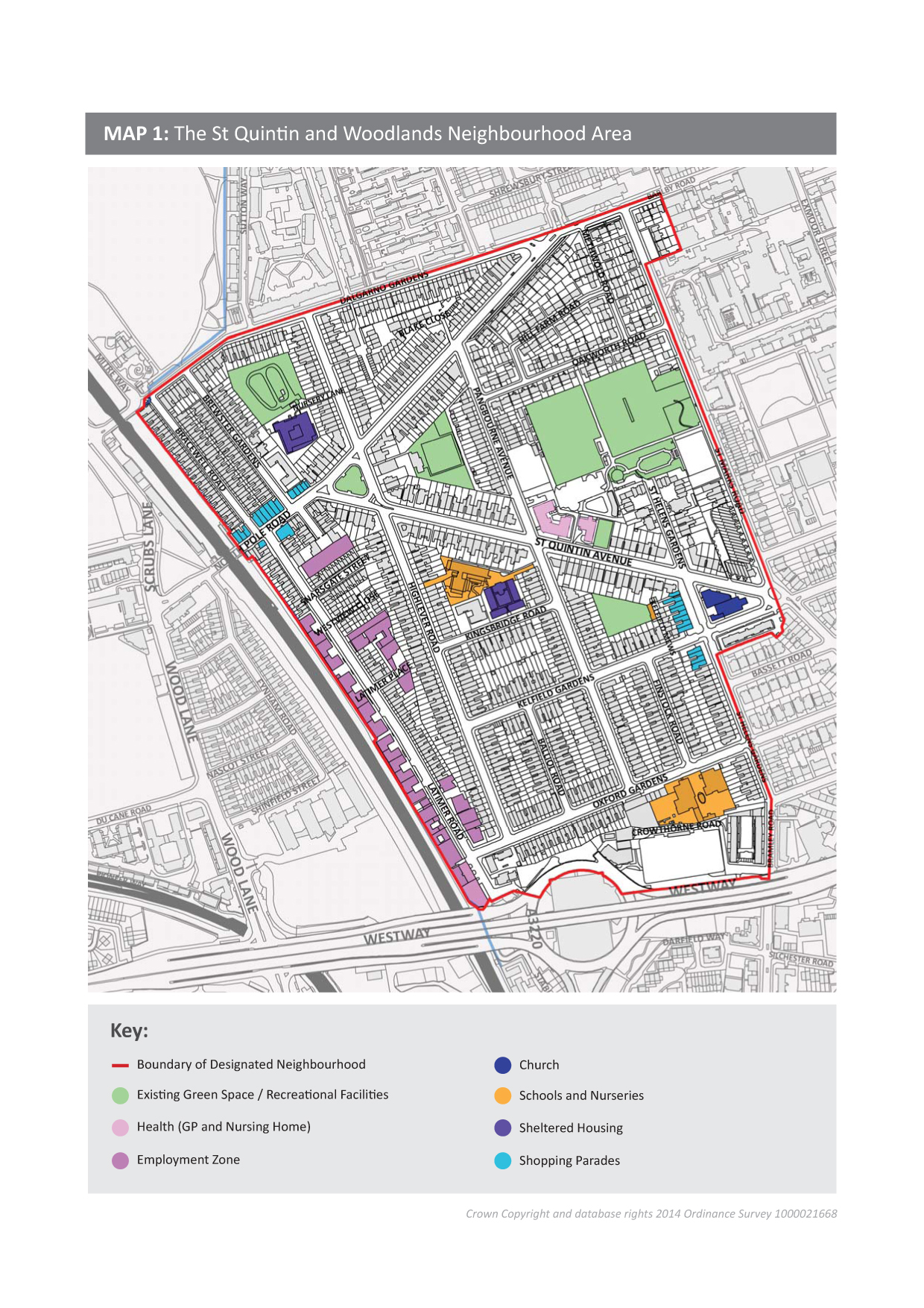
0.1.8 The policies proposed in this Draft Plan relate only to the neighbourhood area designated within RBKC, as shown by the red boundary line in Map 1 overleaf. Those on the electoral register in this area will have the opportunity to vote on the Draft Plan at the local referendum.
0.1.9 The StQW neighbourhood area designated within RBKC covers 42 hectares and includes some 1,700 households, two shopping parades, St Helens Church, and a street (Latimer Road) sections of which are currently designated as an Employment Zone. The neighbourhood area covers parts of the Dalgarno and St Helens wards, and lies within the larger Oxford Gardens Conservation Area.
A brief history of development in the area
0.1.10 The building of the streets and houses in the neighbourhood followed swiftly from the construction of the Hammersmith and City railway across North Kensington (the line opened in 1864). This opened up a previously rural area to landowners and builders eager to invest in London’s westward expansion. Land west of Ladbroke Grove was laid out and developed from 1870-90 by architects and builders engaged by the St Quintin family.
0.1.11 Latimer Road, lying alongside what is now the West London Line, was from the late 1880s onwards an important north/south route running down to Holland Park Avenue. The severance of this route by the construction of the Westway in the late 1960s has had a lasting impact on Latimer Road and on movement and connectivity generally within this part of North Kensington.
0.1.12 A further phase of development to the estate took place between 1891 and 1905 and was undertaken by builders working for W H St Quintin. This involved the building of several hundred red brick family houses in a series of wide terraced streets (with some larger end of terrace houses).

|
0.1.13 After the 1914-18 war other parts of the St Quintin neighbourhood were developed mainly for workers housing by the Kensington Borough Council and by various charitable trusts. In 1919 the Council bought nine acres in the vicinity of Methwold and Oakworth Roads, and by 1926 had built 202 cottages or cottage flats, to designs by the architect A. S. Soutar. These streets were added to the Oxford Gardens/St Quintin Conservation Area in 2002.
0.1.14 The streets to the north of North Pole Road (Bracewell Road, Brewster Gardens, Dalgarno Gardens south side) are made up of Victorian two storey housing. Formerly part of the London Borough of Hammersmith & Fulham, these streets became part of Kensington & Chelsea in 1996. These streets were also added later to the Oxford Gardens Conservation Area.
0.1.15 The nearby areas of Notting Barns and ‘the Potteries’ were notorious in the 19th century as one of London’s worst slums with very high rates of infant mortality and disease. The former Princess Louise Hospital in Pangbourne Avenue, funded through private subscription, was opened in 1928 to provide medical care to the poor. The Kensington Memorial Park, which remains the main public open space within the neighbourhood area, was opened in 1926.
0.1.16 Much of the housing stock built in the area in the late 19th and early 20th centuries was in poor condition by the 1970s, with many houses multi-occupied. The St Lawrence General Improvement Area was declared by RB Kensington & Chelsea in 1984.
0.1.17 The threat of the London Motorway Box in the 1960s (of which only the short section of the West Cross Route was ever built and the remainder of the project abandoned) brought local residents together during that decade. The impact of rail servicing arrangements for the Channel Tunnel was also a threat to the area, now long past.
0.1.18 Hence the neighbourhood has a history of facing challenges resulting from London-wide and national infrastructure projects. Local residents find themselves in this position once again with the proposals for very major commercial and residential development around the planned HS2/Crossrail hub, within the area to be planned and managed by the new Old Oak and Park Royal Development Corporation.
What the neighbourhood plans aims to do
0.1.19 The extent to which neighbourhood plans can influence major infrastructure change is limited. Such change in this part of London is being determined largely by higher level plans (the London Plan, the Old Oak and Park Royal Development Corporation, the GLA/LBHF Opportunity Area Framework for White City, and the Local Plans of RB Kensington & Chelsea and of LB Hammersmith & Fulham.
0.1.20 Within these constraints, a neighbourhood plan can still have significant influence on what happens within a small area. The StQW Neighbourhood Plan:
- introduces policies on employment and housing which will contribute to sustainable development of the neighbourhood and its long-term success, fine-tuning where necessary certain RBKC Local Plan policies.
- provides for residents a clear and understandable set of conservation policies, largely reflecting those that apply Borough-wide while refining these to reflect the character of the neighbourhood and its building types.
- asks RBKC to update the existing Article 4 Directions which already apply to specified streets and part streets within the StQW neighbourhood, and to add two new elements (on overpainting of original brickwork and on garden outbuildings) in order to better protect the heritage of the area (see Section 2 on Conservation).
- proposes policies for the regeneration of Latimer Road, including further residential development, as a part of the neighbourhood which has not fulfilled its potential since the construction of the Westway in the late 1960s.
- contributes to the Borough’s targets for new housing, allocating specific sites for housing use.
- proposes designation as Local Green Space three of the original ‘backlands’ in the Oxford Gardens/St Quintin Conservation Area.
- addresses issues on transport and traffic, with an eye to the greatly increased demands being placed on the local road network as a result of development in the surrounding area.
0.1.21 The scope of a neighbourhood plan is defined in law in what is now Section 38A(2) of the Planning and Compulsory Purchase Act 2004. This establishes that ‘a neighbourhood development plan is a plan which sets out policies (however expressed) in relation to the development and use of land in the whole or any part of a particular neighbourhood area specified in the plan’.
0.1.22 As is the case with many of the neighbourhood plans drawn up to date, some of the proposals in this Plan fall outside a strict definition of ‘development and use of land’. Ideas that have come forward from local people on transport, traffic and community safety are examples.
0.1.23 This Draft Plan uses the term ‘Actions’ to distinguish such recommendations from ‘Policies’. It is the Policies alone which will form the statutory part of this Plan, and which will be applied (subject to a referendum) by RBKC when deciding planning applications.
0.1.24 CLG Planning Practice Guidance recommends that ‘actions’ dealing with other than land use in a neighbourhood plan ‘should be clearly identifiable, for example set out in a companion document or annexe’. In this Draft Plan, the proposed ‘Actions‘ are shown under the relevant subject heading, as this makes the document more coherent for the reader.
0.1.25 In order to keep this Submission Version of the StQW Plan as short as possible, some sections of the earlier Consultation Version have been transferred across to the StQW Basic Conditions Statement. These are sections on which the StQW Forum has needed to provide detailed evidence and justification in order to support the proposals being made. The StQW Draft Plan needs to satisfy and independent Examiner that is it is in ‘general conformity’ with the London Plan and the RBKC Local Plan in order to proceed to a referendum. The Forum believes that these conditions will be met.
0.1.26 In all sections of the Plan
- proposed policies are shown in bold italic red type
- the ‘reasoned justification’ for each policy is shown in bold blue type
- ‘Actions’ are shown in bold green type.
Duration of the StQW Neighbourhood Plan
0.1.27 This Neighbourhood Plan is intended to cover a maximum 10-15 year time period, covering the period from 2015-30. It may require earlier review in the light of the major developments that will be taking place in the surrounding Opportunity Areas, or if RB Kensington & Chelsea make substantial changes to its own Core Strategy/Local Plan.
Evidence base for the Plan
0.1.28 Details of the documents, survey returns, and other information used in the preparation of this Plan are provided as an annexe to the accompanying ‘Basic Conditions Statement’. In summary this material consists of:
- 106 detailed responses to a survey questionnaire circulated to 1,700 households in the neighbourhood area. A response rate of 6% was achieved despite the fact that the survey required significant time input from the respondent.
- interviews with retailers and services in the shopping parades in the neighbourhood and with businesses in Latimer.
- a series of open meetings of the Forum (with attendances ranging from 30 to 80 residents and businesses) plus drop-in sessions and consultation workshops on the various subjects and proposals included within the Plan.
- contact with landowners and agents, on the small number of development sites in the neighbourhood
- discussions with RBKC planning officers
- RBKC and national datasets, reports and evidence as used in the preparation and updating of the RBKC Core Strategy, the LBHF Core Strategy, and various RBKC and LBHF Supplementary Planning Documents.
0.1.29 When using demographic and socio-economic data in this Plan, we have relied largely on the ward profiles published by RBKC. Averaging figures across these two wards gives only a rough approximation for data for the StQW neighbourhood area, as this includes the more affluent parts of the Dalgarno and St Helens wards and this skews average figures.
THE WIDER PLANNING CONTEXT – DEVELOPMENT PRESSURES AND DRIVERS OF CHANGE
0.2.1 The StQW neighbourhood lies within an area of inner west London for which there are a series of major infrastructure and development plans spanning the next 30 years.
0.2.2 Three of London’s thirty three Opportunity Areas surround the neighbourhood. These are Old Oak/Park Royal, White City and Kensal Canalside. Opportunity Areas are designated by the Mayor of London and London Boroughs and are defined in the London Plan as ‘London’s major source of brownfield land with significant capacity for new housing, commercial and other development linked to existing or potential improvements to public transport accessibility‘. Hence these areas are treated in planning terms as being suitable for ‘intensive’ development, with implications for the surrounding areas.
0.2.3 The Old Oak Opportunity Area, immediately north-west of the StQW neighbourhood, stretches across the three boroughs of Hammersmith & Fulham, Brent, and Ealing. This area now forms the eastern part of the land managed by the new Old Oak and Park Royal Development Corporation. This new body went live from April 1st 2015.
0.2.4 Revisions to the London Plan (2014) state that this OPDC area could accommodate ‘substantial development which could yield 24,000 new homes and, subject to capacity and demand, up to 55,000 jobs and a variety of complementary and supporting uses in a commercial hub around the station and in the wider area’. A cluster of very tall buildings is suggested, around the proposed HS2/Crossrail station and interchange (planned to be located north of Wormwood Scrubs).
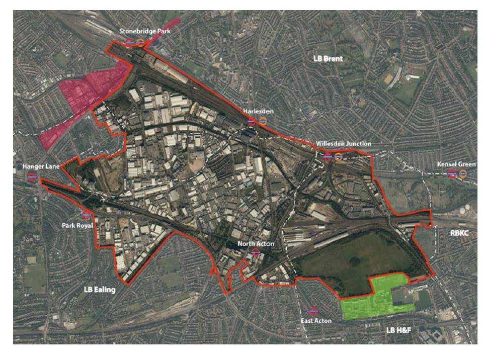
Old Oak and Park Royal Development Corporation Boundary
0.2.5 The Mayor of London in February 2015 published a ‘Planning Framework’ for the Old Oak and Park Royal Area. Once revised, following consultation, this document will become Supplementary Guidance to the Further Alterations to the London Plan.
0.2.6 Queens Park Football Club published in September 2014 a set of very outline proposals for the Old Oak area, and have commissioned a masterplan from the Farrell Partnership. Their proposals involve a new football stadium, with adjacent housing and commercial development. Car Giant own 45 acres of the land within the Development Corporation area and have their own plans for a development of 9,500 homes and a ‘new high street’ and ‘cultural hub’ on their own site. Car Giant state that they oppose the QPR plans and it remains to be seen which (if either) if these proposals prevail at the end of the day. Planning applications are likely to come forward in late 2015.
0.2.7 The White City and Kensal Rise Opportunity Areas are also close to the StQW boundary (in White City’s case immediately across the West London Line behind Latimer Road). Developments here are already impacting very directly on the neighbourhood. The Imperial West site within the White City OA has seen four 10 storey blocks of student housing built by Imperial College in 2011/12 and construction work is now underway on the second phase of this new academic/business campus (the 12 storey Research and Translation hub). Final planning permission was also granted (in 2012) to a 35 storey residential tower adjacent to Wood Lane and the Westway roundabout, yet to be built.
0.2.8 Imperial’s additional land holding south of the Westway (the former Dairy Crest site) now forms part of a combined 25 acre site. Plans for this section of the site have yet to emerge. The College has also revised its original plan for a 13 storey hotel on the Woodlands site, and will now be using this location for a bio-medical engineering centre. A planning application was submitted in April 2015.
0.2.9 RB Kensington & Chelsea’s plans for the Kensal Canalside Opportunity Area remain at an early stage. Several major landowners are involved, and negotiations between them are complex. The Council is also continuing to lobby the Government for a Crossrail station at this location. RBKC published an initial consultation paper for the Kensal Gasworks Strategic Site in mid 2012, but no firm plans have subsequently emerged.
Implications for the StQW Neighbourhood
0.2.10 The scale of development proposed for these Opportunity Areas is massive, by London and even global standards. While it will be 30 years before the full impact on the StQW neighbourhood is seen, the changes will be profound. Three main concerns have emerged in consultation and discussions:
- none of the proposals for individual sites, nor the various planning frameworks and ‘illustrative masterplans’ for the wider area as published to date, explain adequately how the demands on the local road network will be met – particularly the A219 Scrubs Lane/Wood Lane as the main north/south route through the area. This is a major concern for local people, covered in Section 5 of this Draft Plan.
- The western skyline of this part of London currently remains relatively open and unobstructed by tall buildings. This is already changing as a result of development in Hammersmith & Fulham and will change further with the development of Old Oak. There is little that a neighbourhood plan can do to lessen the impact of such developments outside the boundary of the designated neighbourhood.
- the daily experience of residents within the StQW neighbourhood, of being at the edge of inner London, in an enclave originally designed to be more ‘suburban’ than ‘urban’ and with open green spaces and wide and peaceful streets, is at risk of continued erosion. Pressures for housing and commercial development, with resultant increased traffic, will continue. This Neighbourhood Plan can at least ensure that such development is directed to the most suitable locations, within the StQW area.
0.2.11 Local people have expressed strong and consistent views on what should happen on future development within the neighbourhood. Beyond its boundaries, the Forum can only hope that change will prove to be well planned and steered by the wide range of planning authorities and public bodies involved.
The impact of market forces – house prices and commercial rents in the StQW area
0.2.12 The paragraphs above explains what is happening within the formal and statutory processes of the planning system. A separate (and relatively uncontrolled) set of forces is also changing the character, and look and feel of the StQW neighbourhood. History is in a sense repeating itself. A part of London created and built in the late 19th century, as a result of the decisions of investors in railway lines and speculative housing stock, is now seeing its built form, demography and social composition refashioned once again through the market forces of the 21st century.
0.2.13 The workings of the London housing market are having a powerful impact. So are the workings of the commercial market for office space. But the two effects have to date proved to be different in their effect on the StQW neighbourhood.
Impact of the housing market
0.2.14 Local residents are very aware of the impact on the neighbourhood of a London housing market which sees steep price rise, interspersed with significant falls. House prices drive investment in refurbishing existing properties, as well as very strong market demand for any possible development sites, large or small. The neighbourhood has been experiencing both market forces, in recent years. Sections 4, 8 and 10 of this Plan refer to these issues.
Business, retail, and employment activity the neighbourhood
0.2.15 The situation in respect of business and retail activity in the StQW neighbourhood contrasts with that on housing. Whereas residential property is in strong demand, there has been long-term problem of lack of interest in office floorspace at the southern end of Latimer Road. Section 8 of this Draft Plan sets out proposals for the future of Latimer Road. This is a key part of the StQW Plan, but regrettably one on which the Council has made clear that it will object at Examination to the proposals in this Draft Plan.
0.2.16 The StQW neighbourhood area includes two local shopping parades, in North Pole Road and St Helens Gardens, along with smaller clusters of shops in Dalgarno Gardens and Barlby Road. Several shop units have remained vacant in these parades for many years, and this suggests that RBKC policies seeking to protect A1 retail use may have been over -restrictive. A2 or A3 use is preferred by most local residents to a long-term vacant shop. Section 7 of this Plan sets out proposed policies to bring these vacant units back into active use.
0.3 CONSULTATION AND COMMUNITY ENGAGEMENT
0.3.1 Following the inauguration of the StQW Neighbourhood Forum in June 2013, a new management committee was elected. This body looked at a range of ways in which local people could become involved in contributing to the preparation of this neighbourhood plan.
0.3.2 Details of the consultation carried out on this Draft Plan can be found in the separate StQW Consultation Statement.
0.4 HOW THIS NEIGHBOURHOOD PLAN ACHIEVES SUSTAINABLE DEVELOPMENT
0.4.1 Neighbourhood Plans are required ‘to have regard’ to national planning policies set out in the National Planning Policy Framework. This relatively new framework (approved in its final form in 2012) now underpins the planning system across England, and reflects the Government’s approach to meeting international goals for sustainable development across the globe.
0.4.2 The NPPF defines three roles for the planning system.
- an economic role, contributing to a strong, responsive and competitive economy
- a social role, supporting strong, vibrant and healthy communities
- an environmental role – contributing to protecting and enhancing our natural, built and historic environment
0.4.3 Annexe A to this document explains how the StQW Draft Plan relates to these three roles of the planning system.
0.4.4 The NPPF goes on to state (Paragraph 8) that “these roles should not be undertaken in isolation, because they are mutually dependent. Economic growth can secure higher social and environmental standards, and well designed buildings and places can improve the lives of people and communities. Therefore, to achieve sustainable development, economic, social and environmental gains should be sought jointly and simultaneously through the planning system. The planning system should play an active role in guiding development to sustainable solutions“.
0.4.5 In formulating this neighbourhood plan, the StQW Forum has considered carefully how best to balance the weight applied to each of these mutually dependent goals.
0.4.6 The RBKC 2010 Core Strategy/Local Plan identified 14 ‘Places’ in the Borough for which specific sections of the Plan were drafted. The StQW neighbourhood is not one of those areas covered. This was one of the motivations for developing a neighbourhood plan for this part of North Kensington (see StQW designation application)[1].
0.4.7 The Forum has also been mindful of the Sustainability Appraisal developed by the Royal Borough as part of its 2010 Core Strategy/Local Plan. This appraisal, prepared by independent consultants Scott Wilson, analysed the submission version of the council’s Core Strategy in terms of its contribution to sustainability goals. Annexe A to this Plan sets out how each of the 11 sets of policies in this Draft Plan will relate to these RBKC Sustainability Objectives.
0.4.8 Latest Government guidance states that as full Strategic Environmental Assessment (SEA) will rarely be needed for neighbourhood plans. The Council agrees in the case of the StQ Neighbourhood Plan and has consulted on a Screening Opinion to this effect. The three national bodies consulted are Historic England, Natural England, and the Environment Agency.
0.5 VISION AND OBJECTIVES OF THE StQW NEIGHBOURHOOD PLAN
0.5.1 The over-arching vision for the Plan was developed through discussions at the StQW management committee and from responses to the household survey. We have tried to keep it simple. This vision statement was endorsed at the open meeting of the Forum held on July 10th 2014.
To secure the future of a neighbourhood that offers the best features of life in central London, for this and future generations
0.5.2 From this vision, a set of 11 key objectives was developed for the plan. These are as follows:
- Keep the area as an attractive place to live and work, for families and individuals from current and future generations (This reflects the Keeping Life Local theme of the RBKC Core Strategy).
- Fine tune conservation policies to be applied within the neighbourhood, to protect heritage while reflecting contemporary lifestyles and making fully effective use of existing housing stock.
- Protect environmental quality and the neighbourhood’s wide streets and public realm including views within and from the conservation area.
- Protect and enhance our open spaces, gardens and trees, both private and public, bringing backland green areas into community use where ownership permits.
- Reduce traffic queues, noise and disturbance within the neighbourhood and improve pedestrian/cycle connectivity to the south and west.
- Maintain safety, security and tranquillity in the area, contributing to a continued low level of burglary and street crime.
- Safeguard the commercial viability of our shopping parades as sources of local convenience shops and services that residents need.
- Regenerate Latimer Road as a successful mixed use street, combining commercial and housing use, keeping buildings occupied and in active use, and restoring its original street form.
- Maintain and where possible increase employment opportunities in the area.
- Contribute to the Borough’s housing targets and seek out opportunities for building housing affordable to younger generations.
- Protect local education, health and community facilities from commercial development pressures.
0.5.3 Some of these objectives lend themselves more readily than others to being shaped via land use and development planning policies. Those relating to issues such as transport and traffic require greater involvement from both Borough Councils (RBKC and LBHF) and from the GLA and from Transport for London (TfL). A number of proposed ‘Actions’ in the StQW plan are directed towards such involvement.
0.5.4 The National Planning Policy Framework expects local and neighbourhood plans ‘to be based on stated objectives for the future of an area and an understanding and evaluation of its defining characteristics’ (paragraph 58 of the NPPF). The above objectives reflect this aim.
0.5.5 The RBKC Local Plan emphasises of the role of ‘place-shaping’ and in plans which ‘create a locally distinctive approach, tailor-made for the specific locality’ (paragraph 4.1.1 of RBKC 2010 Core Strategy)
0.5.6 The StQW Forum has put in a great deal of time and effort in trying to achieve these goals, and believes that the resultant StQW Draft Plan provides a solid and well supported basis for future planning decisions within the designated neighbourhood area. This view has been confirmed in the independent ‘health-check’ of an earlier draft of the Plan, undertaken by Christopher Lockhart-Mummery QC and included as Annexe A to the StQW Basic Conditions Statement.