Developers Sainsbury’s/Ballymore and Berkeley Homes/St William have been working up planning proposals since 2019 for major developments on the former gas works site to the west of Ladbroke Grove. This landlocked railway land is a Mayoral Opportunity Area and is one of two remaining regeneration areas in Kensington and Chelsea (the other being Earls Court).
The 2016 and 2021 London Plans have allocated Kensal Canalside for mixed use, with an ‘indicative’ housing target of 3,500 new homes. This figure is included as a ‘minimum’ in the site allocation policy in the RBKC 2019 Local Plan.
A Supplementary Planning Document was adopted by RBKC in July 2021. This has suggested potential ‘development capacities’ of up to 5,000 new homes. As yet there is little evidence of these figures having been ‘tested’ via masterplanning, in the way that the London Plan expects the Boroughs to undertake for ‘indicative’ targets.
In October and November 2021, both sets of developers invited the Kensington Society planning committee (which includes the Chair of the StQW Neighbourhood Forum) to presentations and discussions on their proposals. These developers are currently assuming an overall housing delivery figure of around 4,000 new homes across the Opportunity Area.
Notes of these presentation sessions can be downloaded below. These include a commentary by the Kensington Society and provide useful background for a first ever ‘Development Forum’ which RBKC has convened. This will take place at Barlby Primary School on 24th November 2021 from 6pm to 8pm. This session will be open to all, with no need to register.
Kensington and Chelsea Council has introduced an Article 4 Direction which removes national permitted development rights on change of use from commercial to residential use. This will take effect in 2022, if accepted by the Secretary of State.
The Council previously introduced a borough-wide Article 4 Direction removing PD rights on office-to-residential change of use. This further Direction applies to all E class commercial uses and is also proposed to cover the entire Borough.
The Forum argued back in 2017 that a complete ‘borough-wide’ approach is a blunt instrument and that there are some parts of the Borough which need these national planning flexibilities. Latimer Road is one of these areas, as a street where we feel that much needed new housing should be provided.
We take the same position on this latest proposal by the Council and have submitted a response to its recent consultation on this issue – as below.
We also think that the Council is ignoring national policy guidance that Article 4 Directions of this kind, if used, should be applied to the ‘smallest area possible’. We think that RBKC’s approach should have been more selective geographically, and that a ‘borough-wide’ direction will have increased the likelihood of intervention by the Secretary of State. It may be several months before we know whether the Council’s proposal will be allowed to stand.
The Council is revising its 2019 Local Plan and carrying out a series of consultations on its content. A final version is expected to be adopted in 2023.
The second stage of consultation has been on an issues and options paper called the New Local Plan Review (NLPR). The RBKC consultation website is at https://planningconsult.rbkc.gov.uk/NLPR_IandO/consultationHome. The deadline for responses is midnight on October 4th.
The management committee of the StQW Forum/St Helens Residents Association has drawn up a response which you can read below or download as a draft. If you have any comments or suggestions to make, please email sthelensassn@aol.com by lunchtime on Monday 4th October.
The heavy downpour on July 12th 2021 caused flash flooding in several parts of North Kensington. While the StQW neighbourhood was largely spared, there was some flooding of ground floors at the southern end of Latimer Road.
Subsequently Felicity Buchan MP arranged an online session for residents to question Thames Water on why the street drainage/sewerage system was overwhelmed by surface water run-off. The basic response from Thames Water was that their systems performed ‘as designed’. This is hardly encouraging for those in the Borough who suffered serious flooding of their basements.
Was this a one in 10, 20 or 50 year rainfall event? The storm did not feel that unusual given the way that UK weather has performed this summer.
A further set of written responses from Thames Water can read or downloaded below.
The risk of surface water flooding in some of the streets in our neighbourhood is very real. The Counters Creek main sewer, which takes surface water from a wide catchment areas, has been overloaded for years. A major replacement project was abandoned by Thames Water in 2017.
Every year we remind local residents that paving over front gardens with impermeable surfaces and without planning permission is a breach of planning controls. While there are many such examples already in place in the neighbourhood, the Council is likely to take enforcement action on new cases.
RBKC planning policies requires installation of Sustainable Urban Drainage Systems (SUDS) for basement projects. But there are questions over the extent to which these, and the use of FLIPS (Flooding Local Improvement Process) can be relied up to address risks. It looks as though the Council will tighten up on this aspect of basement policies in the next version of the Borough’s Local Plan (currently in preparation. Meanwhile the StQW Forum is questioning with RBKC the safety and risks to life of continuing to give planning consent to basements that include bedrooms in addition to living areas.
The consultation undertaken by the Old Oak and Park Royal Development Corporation on its Post Submission Modified Draft Local Plan finished on July 5th. We prepared a second set of detailed representations, which were submitted to the OPDC.
The Development Corporaation now reviews all the submissions made, and prepares reponsed to these before passing them on to Planning Inspector Paul Clark. The Inspector;s final report on the Draft Plan is not expected for several months.
Our comments were summarised below in our representations. We are aware that Hammersmith & Fulham Council, the Friends of Wormwood Scrubs, Friends of Little Scrubs, and the Hammersmith Society sent in responses making many of the same points.
• We consider the consultation material, including online sessions and the sub-site set up by OPDC to be inadequate for reasons explained below. The magnitude of the changed spatial and transport elements of the Draft Plan was seriously understated by OPDC. • Anyone reading the Table of Modifications alone might well not even notice the fundamental changes relating to Old Oak North, Scrubs Lane, Channel Gate and transport infrastructure. • Unmodified parts of the Plan continue to make exaggerated and unevidenced claims for the ‘connectivity’ of ‘Places’ at Old Oak and the impact that the OOC rail interchange will have on the wider area of West London. • This impact will emerge only after 2030 by which time this PSMDLP will need to have been reviewed once if not twice. • Levels of uncertainty on funding for infrastructure remain very high. For the next 10 years until OOC station is in operation, OPDC and Mayoral ambitions for the area should be scaled back – particularly at a time of major change resulting from the pandemic. • With a high probability of no new Overground stations and no new east-west road connection between East Acton and North Hammersmith, the whole coherence of the 19.2 version of the Draft Local Plan is undermined. • We are not persuaded by the content of the BNP Paribas Strategic Site Allocations Viability Study (see Annex C). • Entirely new proposals for concentrations of very high density and high rise housing are introduced as modifications to a Local Plan already 3 years into its examination stage. • Proposals for a ‘major Old Oak town centre’ are unclear and incoherent. • Lack of adequate new public transport improvements means that proposals at Channel Gate and Scrubs Lane will not conform with 2021 London Plan policy. • There is no evidence that the Duty of Co-operation with neighbouring Boroughs has continued to be met since September 2018, and some evidence to the contrary.
Our full ‘Part 2’ response is too large a file to be added here as a download. But please email inf@stqw,org if you would like a copy. See also our earlier post for Part 1 of our representations.
We will continue to arge that OPDC should make a fresh start on what is a ‘modified’ Draft Local Plan which no longer sets out a coherent set of future proposals for the Old Oak area. .
This Draft Local Plan form the Old Oak and Park Royal Development Corporation was ‘submitted for examination’ as long ago as October 2018. After a series of public hearings the following year, Planning Inspector Paul Clark issued ‘interim findings’ and ruled that the Plan’s proposals for locating new housing on the 45 acres of land owned by Cargiant were not viable.
This meant that the OPDC had to look around for new housing sites. It spent 16 months doing so and in March 2021 submitted a set of ‘modifications’ to its part examined Draft Local Plan.
Usually such modifications are relatively minor tweaks. But in this case, the changes are very substantial. Gone are plans for ‘Old Oak Park’ and an new Overground station at Hythe Road. New housing sites are being identified in East Acton (labelled by OPDC as the ‘Western Lands’) and at Scrubs Lane. The part of the plan located in Ealing now has no road connection planned with the part of the plan in North Hammersmith. These are effectively two separate Local Plans.
This is not the joined up and coherent vision for a new Old Oak that was promised back in 2015. The StQW Forum has been working closely with the Old Oak Neighbourhood Forum since 2016 in responding to OPDC proposals. The more we have looked at the details, the less convincing is this 2021 version of a Draft Local Plan. This does not feel like the best solution for regeneration of this part of London.
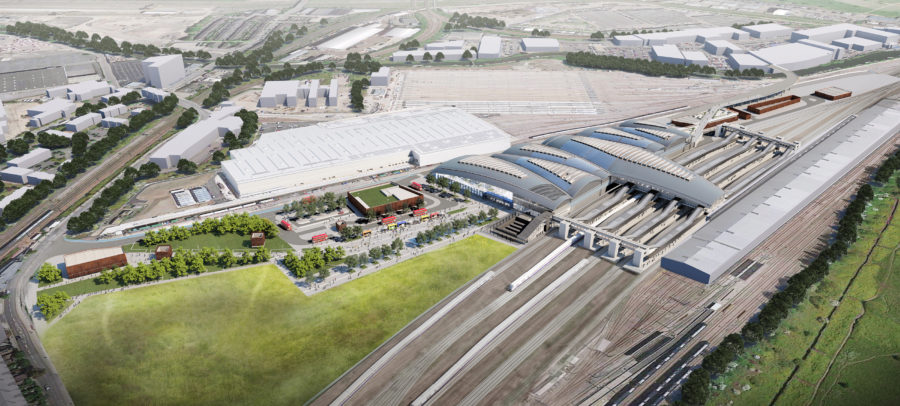
The timing now makes little sense. Completion of the HS2/GWR/Crossrail station is not now scheduled until sometime between 2029 and 2033. There is a decade of construction work yet to happen. The new station has a cost estimate of £1.7bn, will be 1km in length, and yet will now have no vehicle access at its eastern end. So no means of arriving at or departing from the station on this side of the Scrubs, other than via the canal towpath at Mitre Bridge. Claims that this rail interchange will be a ‘catalyst’ with a ‘transformative’ effect for our part of London no longer stack up.
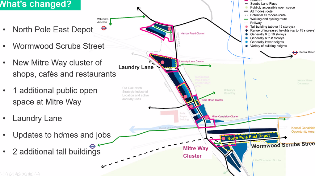
In their search for further housing sites, OPDC planners have added a fifth ‘cluster’ along Scrubs Lane, at the site known as the North Pole Depot (to the north of the Mitre Bridge Industrial Estate). This is earmarked as a housing site with further tall buildings, although it is not yet clear how road access will be provided.
Our Forum has joined forces with the Old Oak Neighbourhood Forum in submitting a set of representations to Planning Inspector Paul Clark, midway through the consultation. This will be followed up with detailed comments on the ‘modifications’
We hope local residents will share our view that the OPDC’s Post Submission Modified Draft Local Plan does not meet the legal tests of ‘soundness’ and should not proceed to adoption. There is time for a different and better Plan to be prepared, taking account of all that has changed for the future of London as a result of the pandemic as well as changes in London Plan policy towards further tall buildings in the city.
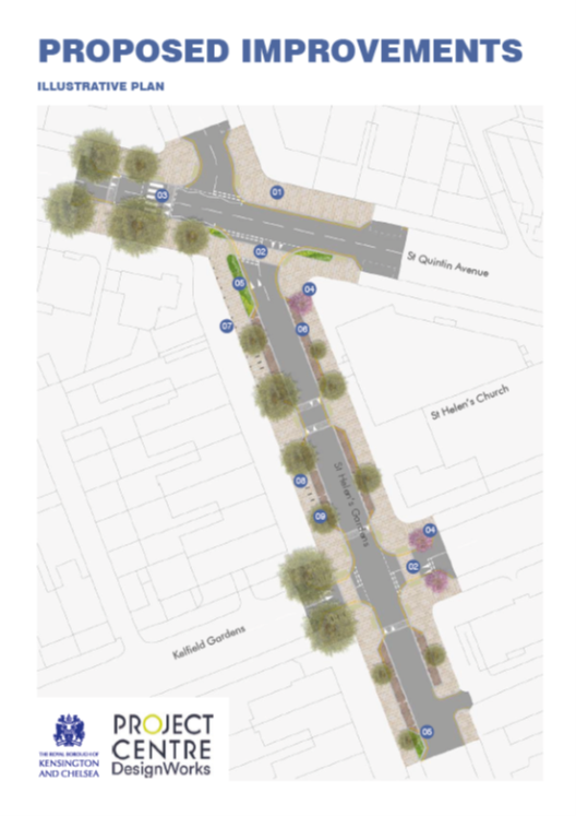
The Council at the end of April 2021 launched a consultation on a set of improvements to St Helens Gardens. These were aimed at making the street more pedestrian-friendly and safer in terms of traffic speeds. The deadline was June 15th.
We held an open Zoom session for all members on June 10th to discuss the proposals, some of which had strong support while others did not. Using Zoom polls, we were able to capture everyone’s views on the specific elements of the scheme.
Our final consultation response, including the results of the Zoom polls can be downloaded at the link below:
The strongest support was for a new Zebra crossing on St Quintin Avenue, just south of the junction with St Helens Gardens. This should slow traffic on a stretch of road where speeding has always been a problem and where the 20mph limit is widely ignored.
Other proposals were less popular or seen as not needed. We have asked for any savings from the original proposals to be diverted to renewing the paving in North Pole Road – seen as a higher priority than installing porphyry setts in the parking bays of St Helens Gardens. There was a also a majority for retaining all current parking bays in the street rather than adding a raised crossing (not a full zebra) roughly opposite the church gates.
The Council will now consider all responses to the consultation and decide which parts of the overall scheme to put in place. The works are due to place later this year,
The Council has been consulting in recent weeks on two consultation documents on Latimer Road. Members who took part on our AGM on 13th May discussed both of these. At the end of these discussions views on a number of questions and statements were collected via Zoom polls.
Our responses, in final draft form, can be read and downloaded at the links below. These will be submitted to the Council late on 19th May to meet the consultation deadline.
Any final comments should be sent to sthelensassn@aol.com
Consultation on streetscape improvements in St Helens Gardens
One further RBKC consultation on stretscape and traffic safety measures in St Helens Gardens runs until June 14th. In this instance the Council has a circulated a hard copy leaflet to household shops in the immediate area, but not the whole neighbourhood.
We will hold a further Zoom session open to all members, in early June to discuss a response.
RBKC is currently consulting on proposals to extend the boundary of the the Oxford Gardens/St Quintin Conservation Area to include certain sections of Latimer Road.
The Conservation Area was originally designated in 1975. The boundary was extended in 2002 to take in Brewster Gardens and Bracewell Road.
For owners of all types of property than can be perceived pros and cons as a result of location within a conservation area. For houses, there is evidence of increased values (provided that conservation policies are adequately enforced by the local authority). The downside can be increased controls and restrictions on alterations, particularly on roofs, installation of rooflights, rear dormers, frontages or parts of the property where changes are seen as causing harm to the heritage of the area.
The interrelationships between national Permitted Development Rights, Article 4 Directions (which withdraw such rights in specified streets) is complicated. Add to this conservation policies in the RBKC Local Plan and in the StQW Neighbourhood Plan and research is needed to check what rules may apply.
The StQW Neighbourhood Plan at Annex A (page 73) seeks to explain these interrelationships. But Government has changed national Permitted Development Rights since we drew up the Plan.
We have asked the Council’s conservation staff to give us a summary of the current position, on the effects of a property finding itself in a newly designated part of a Conservation Area. We hope that this will be of help to those considering how to respond to the current Latimer Road consultation. This guidance is below:
You are not able to have the large – up to 8 m deep and 4 m high – rear extensions but otherwise the normal pd rights for enlargement, improvement or other alteration apply with the exceptions of cladding of any part of the exterior of the house with stone, artificial stone, pebble dash, render, timber, plastic or tiles; where the enlarged part of the house would extend beyond a wall forming a side elevation of the original house; or where the enlarged part of the house would have more than a single storey and extend beyond the rear wall of the original house; or where any total enlargement (that is the enlarged part together with any existing enlargement of the original house to which it will be joined) would exceed 50% of the total area of the curtilage (excluding the ground area of the original house) or the height of the part of the house enlarged, improved or altered would exceed the height of the highest part of the roof of the existing house.
It is not possible in a conservation area to take advantage of the recent changes allowing additional storeys to houses.
Normal pd rights apply relating to creation of ancillary outhouses, pools, enclosures etc. for enjoyment of the dwellinghouse, with the single restriction that in land within the curtilage of a house in a conservation area development is not permitted if any part of the building, enclosure, pool or container would be situated on land between a wall forming a side elevation of the house and the boundary of the curtilage of the house.
Normal pd rights apply in relation to the installation, alteration or replacement of a chimney, flue or soil and vent pipe on a dwellinghouse except on roof slopes fronting a highway or on the principal or side elevation of the house. Similarly, normal pd rights apply for installing microwave antennae (satellite dishes) except on a chimney, wall or roof slope which faces onto and is visible from a highway or on a building of over 15 m high.
However, provided there is no relevant Article 4 Direction normal permitted development rights apply in conservation areas in relation to additions or alterations to roofs; erection of porches; provision of hard surfaces; Exterior painting; and provision of electrical outlets electric upstands for charging vehicles; the erection, construction, maintenance, improvement or alteration of a gate, fence, wall or other means of enclosure; and creation of a means of access to a highway.
In more general planning terms, the Council has a legal duty to preserve the character and appearance of the conservation area, meaning that the effects of any development on this will have to be given careful consideration and weight in planning decisions.
The StQW Neighbourhood Plan gives other information on RBKC policies of which houseowners often seem unaware. It also explains which streets are covered by Article 4 Directions removing certain national Permitted Development Rights. Planning permission may be needed to change front boundary walls or install a bike and bin store of any size. Paving over front gardens with impermeable surfaces is a potential breach of planning controls. So if in doubt, best to contact the Conservation team at RBKC.
Back in November 2019, the Old Oak ad Park Royal Development Corporation announced a ‘change of direction’ and a ‘new focus’ for its much delayed Local Plan.
An interim report from Planning Inspector Paul Clark had ended the Development Corporation’s aspirations for a new town centre and 6,000 new homes, to be built on the 46 acres of land owned by Cargiant at Hythe Road. Cargiant had decided to stay put and expand its business on its existing site. The planning inspector concluded that attempts by OPDC to compulsory purchase the land it needed were financially unviable.
This meant further delays on a Draft Local Plan, then already three years behind schedule. An original timetable of Local Plan adoption in Spring 2017 has now slipped 4.5 years to Autumn 2021 with this date far from certain.
During 2020, the OPDC planners have been working up an alternative strategy and a set of ‘modifications’ to the existing Draft Local Plan. This involves a shift of focus away from Hythe Road and towards East Acton. OPDC has christened this area the ‘Western Lands’. Two large sites at Atlas Road and Channel Gate on Victoria Road/Old Oak Lane are planned as the location for a ‘major new town centre’ along with 3,000 new homes.
For our StQW neighbourhood, the abandonment of plans for ‘Old Oak Park’ on the Cargiant land has removed the risks of steadily increased traffic congestion on Scrubs Lane and Wood Lane. But OPDC remain determined to meet their long-term housing target of 24,500 housing units at Old Oak, with nearly 14,000 of these to be delivered in the first ten years of their Local Plan. Hence the hunt has been on to identify extra housing sites that can be brought forward to make up the gap created by the loss of the Cargiant land.
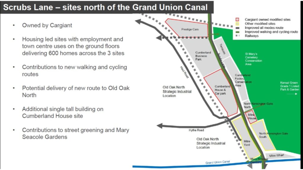
Three sites along Scrubs Lane, owned by Cargiant but separate from their main operations, have been added to OPDC’s revised plans. These are shown above and are destined to be developed for a total of 600 housing units. On the site of the existing Cumberland House, an ‘additional single tall building’ will be allowed under the Local Plan.
In 2017/18 the OPDC Planning Committee granted planning consent to three other tall buildings along Scrubs Lane, at 2 Scrubs Lane, ‘Mitre Yard’, and ‘North Kensington Gate’. The latter two sites have City & Docklands as the developer. These residential towers are all planned to be above 20 storeys. The site at Mitre Yard has been cleared for construction, while City & Docklands are in the process of seeking permission for an extra 40 housing units at North Kensington Gate (South).
As a location very very high density residential towers, Scrubs Lane now makes little or no sense in planning terms. There will be no new town centre next door at Old Oak Park. There will be no new Overground station at Hythe Road, as once promised in the OPDC Local Plan. Access to public transport is very poor, with a 15 minute walk to Willesden Junction. Shops, GP surgeries and other basic amenities are lacking. So there must now be some doubt whether developers will build out these schemes, in a very uncertain London property market.
The StQW Forum continues to submit objections to the latest application at North Kensington Gate South and our latest letter can be found here
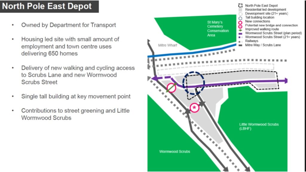
A large site on which OPDC now intends to ‘accelerate’ development is the eastern part of the North Pole Rail Depot at Mitre Bridge on Scrubs Lane. Railway use of this land dates back to the 19th century and the depot has housed rolling stock from Eurostar and now Great Western Railways (GWR). The land is owned by the Department of Transport.
This site was previously planned to come forward for development in later phases of the Old Oak Local Plan. It is not yet clear exactly when the site will be available for redevelopment, to accommodate a proposed 600 new homes. The diagram above (from November 2019 OPDC consultation sessions) also appears to show the Mitre Industrial Estate as allocated for ‘residential-led development’ in due course.
Road access to the Depot site is currently limited to a access track running alongside the rail lines from Ladbroke Grove. The above diagram shows a new road link to Scrubs Lane (in a broken purple line) which the key explains will not be in place for ’21+ years’. A new tunnel beneath the West London Line would be needed.
A proposed ‘Wormwood Scrubs Street’ would connect eastwards to the Kensal Canalside Opportunity Area in RBKC. But if this and the existing Mitre Way are to be the only vehicle access routes to the North Pole Depot site, these proposed 600 new homes will remain isolated and distant from the local road network.
New development at this site is likely to impact severely on views from Little Wormwood Scrubs. OPDC are always very coy about housing densities and building heights when proposing site allocations in their Draft Local Plan. But from past experience these densities will prove to be at 500-600 units per hectare (commonly termed a ‘super-density’ or ‘hyper-density’). This is double the level at which RBKC works to, when undertaking estate renewal schemes such as Wornington Phases 1-3 north of Golborne Road.
The OPDC treats its 24,500 housing target as an unalterable fixture, despite the fact that this figure was largely plucked out of the air to be included in the 2016 London Plan. The New London Plan, now finally adopted, retains this figure. But there is growing demand across London for Opportunity Area housing targets to be re-examined.
Secretary of State Robert Jenrick has intervened, in the final stages of preparation of the New London Plan, to require tall buildings to be limited to locations identified in Local Plans and to encourage ‘gentle densification’ of existing neighbourhoods. The OPDC Draft Local Plan has a way to go before its adoption, including a further set of examination hearings during 2021.
The StQW Forum, the Old Oak Neighbourhood Forum, and other local groups will be making our voices heard at these examination sessions. Londoners are all too well aware that Covid, high rise towers reliant on lifts, and lack access to any private open space, are not a good combination.
